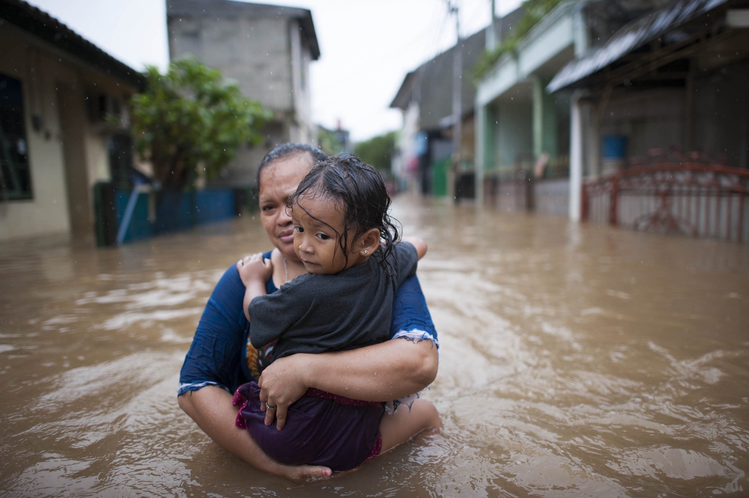
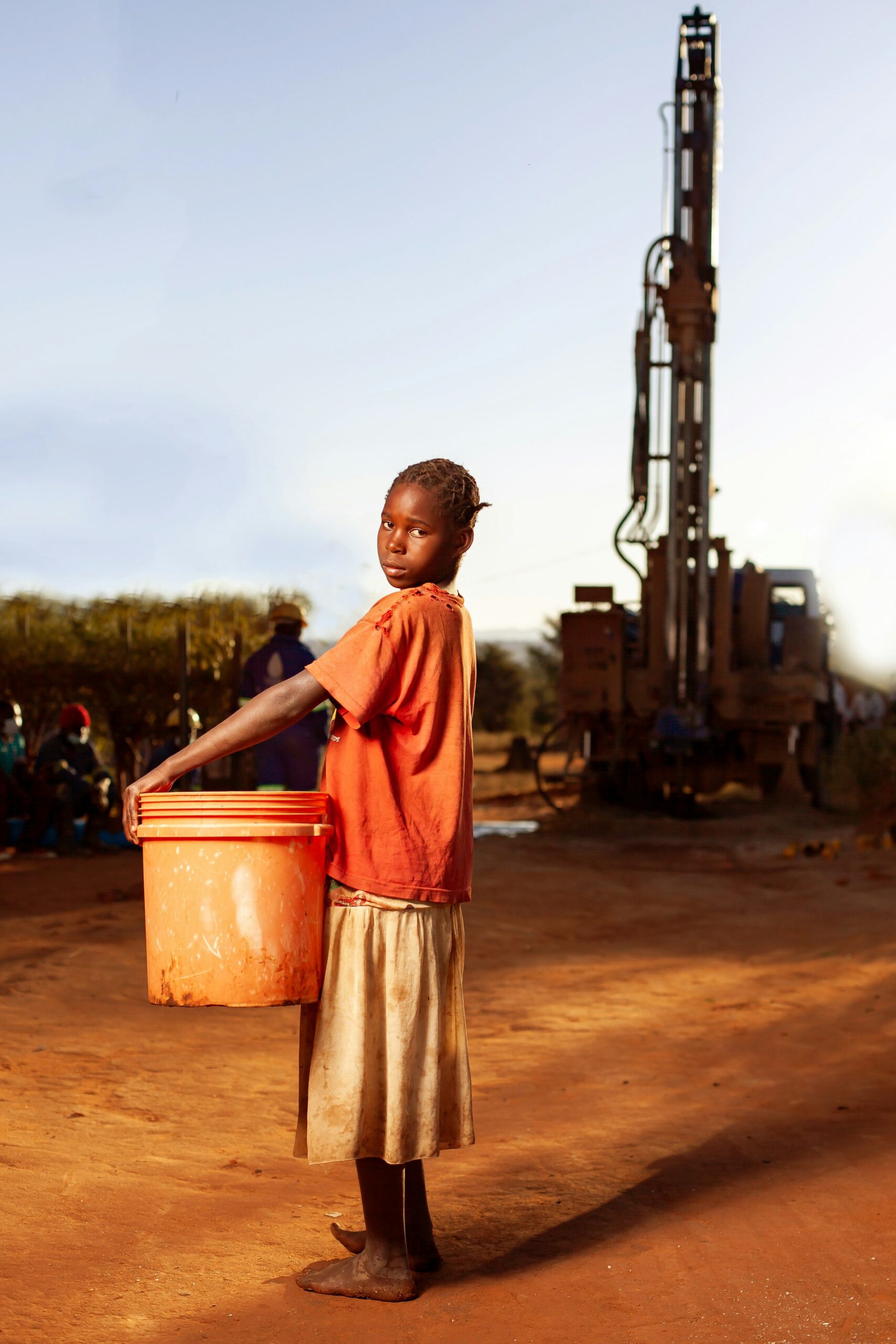
Explore By

This site uses cookies.

This site uses cookies to improve your online experience. To learn more about how we use cookies, please see our terms of use.

Climate and Health Explained

Fueled by climate change, more frequent extreme climate events and other changes to our planet have a fundamental impact on human health and well-being.

Learn More Woman wearing mask

Quick Facts

50% %

Only 48 of 95 countries have completed a climate change and health vulnerability and adaptation assessment, and in only 9 countries did these strongly influenced resource allocation.3 32022 Global Report of the Lancet Countdown

Explore by Map

Using citizen science to identify the water and sanitation needs of homeless populations in Mexico City

This case study is part of the SEI Urban Toolbox for Liveable Cities which has been developed by the SEI Initiative on City Health and Wellbeing. The Urban Toolbox is a collection of tools, developed within SEI or in coordination with SEI, aimed at supporting planning and decision-making for improving the health, well-being and resilience of city residents and urban systems more broadly. It demonstrates how a co-created citizen science approach can be used to assess air quality in an urban area.

Predicting exposure to pathogens and AMR

With increasing sea temperatures it is essential to understand what impact climate change has on the ability of pathogens and antimicrobial resistant organisms to survive and proliferate in our coastal waters. Runoff from agricultural lands and discharges of treated and untreated human sewage can introduce pathogens and antimicrobial resistant organisms to our coastal waters. Researchers from the University of Galway together with colleagues from Bangor University, Deltares, and the University of Exeter are investigating whether modelling can be used to assess the movement of pathogens and antimicrobial resistant organisms in coastal environments.

A model to identify real-time pathogen risks

How can we use a modelling approach to predict the movement of waterborne bacteria and viruses, especially in a notoriously tricky coastal location? This is the challenge a team from Bangor University is facing, along with colleagues from water and subsurface specialists Deltares, Istituto Superiroe di Sanità (ISS) and the University of Exeter.The 55 km-long River Conwy (Afon Conwy) rises in the moors of Snowdonia, widening into the Conwy Estuary near Conwy itself before flowing into the Irish Sea. It’s a well-known beauty spot and tourism destination; however the river and its catchment (the surrounding area where rainwater collects) have a long history of microbiological pollution. With shellfisheries on the Conwy as well as recreational activities, the risk of impact on public health is high.

Real-time risk mapping to inform river users

Can modelling be used to predict the movement of pathogens in coastal environments? A team from Bangor University worked with water and subsurface specialists Deltares and Exeter University to create a real-time risk alert system.The River Camel in Cornwall is one of the three case studies in this project. The Camel rises on Bodmin Moor, and runs for 48km into the Celtic Sea. It has a catchment (the surrounding area where rainwater collects) of 413 km2, and the water flowing into the river suffers from wastewater pollution and agricultural run-off. The poor water quality significantly affects its thriving recreational and shellfishing industries.

A pilot study for the One Health Living Lab

One Health is an interdisciplinary approach that examines the relationships and intersections between humans, animals and the environment. This case study looks at a pilot study in the Plentzia Estuary, which is pivotal in the development of a One Health Living Lab (a research environment that takes a collaborative approach to problem solving).The Plentzia Estuary is in the Bay of Biscay, home to popular tourist resorts. Other human impacts include industrial and farming activities in the Plenzia’s catchment area , as well as a wastewater treatment plant. There’s also a squid fishery that supplies local restaurants.

Evaluating a bathing water quality app

There have been two big news stories about European coasts recently. One: people are increasingly embracing the health and wellbeing benefits of our coastal waters. Two: our seas are at risk from sewage and run-off pollution, which enter the water and introduce pathogens (bacteria, viruses, fungi and parasites). These two marine headlines don’t co-exist happily.Pathogens can be found in our coastal waters due to pollution. Contact with contaminated coastal water can cause ear infections, skin rashes, respiratory illness, diarrhea and stomach cramps, as well as more serious infections in some cases. Are real-time water-quality alerts effective at reducing people’s exposure to these waterborne infections?A team of researchers from the Universities of Exeter and Galway are working together to answer this question. Together they will evaluate and enhance the effectiveness of sharing bathing water quality information to water users via Surfers Against Sewage’s free smartphone app, the Safer Seas and Rivers Service.

A tool to support local climate adaptations

How do local stakeholders prepare for climate change? The effects of climate change are wide-ranging, covering all sorts of sectors from health care to housing. Geography also has an impact, with coastal and inland regions experiencing different issues.To help support local authorities such as councils, the NHS and transport planners, a team from the University of Exeter and Cornwall Council are developing a multi-agency tool that can support local decision-makers to understand the implications of climate change in their area and make recommendations for action. The prototype was developed for Cornwall and the Isles of Scilly, and it is now being further developed across the country.Here’s a bit more about the Local Climate Adaptation Tool (LCAT) and the plans for its future development and use.

Predicting Health Risks for Swimmers

With climate change causing sea temperatures to rise, bathing may become less safe. Bacteria thrive in these warmer waters. Sewage overflows and surface runoff from agriculture may bring nutrients and pathogens into the coastal waters. Current water quality monitoring programs are based on fortnightly sampling and may miss important polluting events.Researchers at Deltares are developing an early warning system to inform people about the real time quality of coastal bathing water.

Does information about water quality change behaviour?

If we know the water quality is poor, do we still go in for a swim? Does the source of this information affect our choices? These are the questions asked by the researchers at the University of Warsaw, as they examine the effectiveness of information regarding waterborne health risks.Their research centres around the Gulf of Gdańsk, which welcomes over seven million tourists each year, on top of a population of around 1.6 million residents. Recent problems with water pollution in Poland could profoundly affect tourism and public health, and the impact of climate change will only cause more problems. How can communication help?

How climate change affects bacterial communities

With climate change causing sea temperatures to rise, bathing may become less safe. Bacteria such as Vibrio, which can infect humans, thrive in these warmer waters, as do harmful algal blooms.Our study looks at the impact of climate change on bacterial communities and algal blooms. How can we better understand this relationship, and from our research, develop strategies to protect human health?A team from Deltares along with researchers from the Universities of Exeter and Bangor are getting up close to Vibrio and faecal bacteria (in the hope that we won’t have to).

Sampling methods along the Arrone River

Surface water sampling is an essential part of the study of waterborne pathogens. However, it’s a complex and delicate procedure that can give misleading results. A team of researchers from the Istituto Superiore di Sanità (ISS) in Italy are undertaking an evaluation of sampling methods, using the Arrone River as their test site.The Arrone River flows from Lake Bracciano (which is a drinking water reservoir) to the Tyrrhenian Sea. It’s 35km long, with a catchment area of 125km2. The surrounding land is mainly agricultural, and this, combined with two wastewater treatment plants, means that the presence of waterborne pathogens can be high.

The spread of antimicrobial-resistant pathogens

How are climate change and environmental pollution affecting the spread of pathogens in water? This isn’t fully understood yet, which is why a team from the Istituto Superiore di Sanità (ISS) in Italy is researching the potential spread of pathogens (PSP).Their test site is Lake Paola, also known as Lake Sabaudia. It’s a coastal brackish lake in Lazio, with an area of about 3.9km2. The study will focus particularly on the antibiotic-resistant profiles of pathogens, which is of great concern to public health.

Modelling risks due to urban transformation and climate change scenarios

Climate change scenarios for Rotterdam show multiple future challenges. With rising temperatures, heat stress due to the urban heat island effect is increasing. With rising sea levels, the influx of saltwater into the river delta around Rotterdam is increasing. Peak weather events will lead to challenges for water storage both in the city of Rotterdam and its surrounding areas close to the Rhine and Meuse rivers. Urban transformation and other adaptation measures to overcome these challenges might affect mosquito, rodent, and bird populations.

Mosquitoes: From Nuisance to Public Health Concern

n Germany mosquitoes were traditionally considered a nuisance. In recent years, the detection of arboviruses, like West Nile Virus (WNV), in domestic mosquito species (as well as in animal and human hosts) and the emergence of invasive species, like Aedes Albopictus, which transmit several highly pathogenic viruses for humans, resulted in mosquitoes also being considered a risk factor for disease transmission. Therefore, since about a decade, several national and regional mosquito monitoring and arbovirus surveillance projects have been initiated.

Safeguarding Sweden’s population against ticks

The first records of adult Hyalomma marginatum and H. rufipes ticks in Sweden were reported in 2018 (Grandi et al., 2019). These findings were the starting point of a new surveillance report system at the National Veterinary Institute (SVA) where the general public was encouraged to send photos of uncommon/exotic ticks. Since 2018, repeated findings of adults of alien tick species (e.g., H. marginatum, H. rufipes and Dermacentor reticulatus) have been reported in Sweden. Climate change is probably one explanation for this trend. Monitoring alien ticks is highly relevant since they could introduce new zoonotic tick-borne pathogens.

COP28 Prospectus of Climate & Health Solutions

This COP28 Prospectus of Climate & Health Solutions presents case studies on a range of high-impact, evidence-backed interventions that can be rapidly scaled up to address climate change while simultaneously achieving health gains. The case studies featured here demonstrate solutions that have been implemented in countries at different levels of health sector performance, resourcing and maturity. The examples included here are neither comprehensive nor exclusive; instead, they aim to illustrate the diversity and scope of climate and health solutions already being implemented.

Guidance Notes on Prevention of Heat Stroke at Work

The hot and humid summer in Hong Kong poses an increased risk of heat stroke to employees working outdoors (e.g. construction, cleaning, security, landscaping, etc.) or in indoor environments that lack air conditioning systems (e.g. electrical and mechanical staff). In addition, employees who are required to work near heat sources or heat-generating facilities (e.g. boilers) are also at risk of heat stroke. This Guidance Notes outlines various factors that employers have to consider when conducting risk assessments for employees, including working environment, work nature and personal factors, and introduces preventive and control measures that are applicable to different risk factors. It helps employers implement appropriate preventive and control measures according to the actual work situation, such as arranging suitable work and rest schedules, to reduce the risk of heat stroke posed to employees working in hot environments.

Zero regrets: scaling up action on climate change mitigation and adaptation for health in the WHO European Region, second edition. Key messages from the Working Group on Health in Climate Change

The imperative to protect and improve the health of current and future generations is one of the strongest arguments for action on climate change and sustainable development. This paper emphasizes the importance of taking proactive measures by the Member States in the WHO European Region to address climate change and its impact on human health, without incurring regrets in the future for missed opportunities. It encourages implementation of strategies that not only reduce greenhouse gas emissions but also enhance resilience and preparedness in health-care systems, promoting sustainable and healthy communities. The paper aims to provide a backdrop and to support uptake and implementation of the climate change and health-related commitments put forward by Member States at the Seventh Ministerial Conference on Environment and Health in Budapest, Hungary, on 5–7 July 2023, and the health messaging during upcoming engagements on climate change and health.

Available in: EN, RU

Observatório de Clima e Saúde de Brasil

O Observatório de Clima e Saúde tem como missão reunir e compartilhar informações, tecnologias e conhecimentos voltados para o desenvolvimento de redes de pesquisadores e estudos que avaliem os impactos das mudanças ambientais e climáticas na saúde da população brasileira. Também busca fornecer contribuições relacionadas à interação clima-saúde que orientem o serviço e o planejamento de políticas públicas nessa área. O projeto objetiva alinhar suas atribuições com a missão proposta pelo Instituto de Comunicação e Informação Científica e Tecnológica em Saúde (Icict), bem como pela Fundação Oswaldo Cruz (Fiocruz) e o Sistema Único de Saúde (SUS).

Health benefits of raising ambition in Colombia’s nationally determined contribution (‎NDC)‎: WHO technical report

This technical report outlines the rationale, process and results of a joint research study, coordinated by the World Health Organization (WHO) and the Pan-American Health Organization (PAHO), co-chaired by the Ministry of Health and Social Protection and the Ministry of Environment and Sustainable Development in collaboration with the Climate and Climate Air Coalition, the Stockholm Environment Institute, the Clean Air Institute and leading international and national experts. A rationale section describes the links between greenhouse gas (GHG) emissions, short-lived climate pollutants, air pollution and adverse health outcomes. A summary of the research study describes how scenarios were modelled to examine the health and economic implications of raising ambition in Colombia’s Nationally Determined Contribution (NDC) to the United Nations Framework Convention on Climate Change (UNFCCC).

How Is India Adapting to Heatwaves?: An Assessment of Heat Action Plans With Insights for Transformative Climate Action

In this report, we conduct what is, to our knowledge, the first critical review of heat action plans in India. We analyse 37 heat action plans at the city (9), district (13) and state (15) levels across 18 states and identify several opportunities to strengthen Indian HAPs. We also document an encouragingly wide range of solutions (covering 62 distinct intervention types) prescribed across these HAPs, from promoting green roofs to state-wide school awareness programs. This lays out a consolidated toolbox of options for the Indian HAP designer and policymaker.

Environmental Stewardship: An implementation guide for boards, executive leaders, and clinical staff: Meeting hospital standards and beyond

This guidebook provides an overview of some of the key steps and actions that senior leaders can initiate and support for their hospital to move towards a climate-resilient, carbon net-zero, and environmentally sustainable health system. Rather than a comprehensive overview, this document is intended to be a primer to help hospitals with their transition to a greener system: from those starting their journey to those looking for new ideas to implement within an already robust sustainable system.

Environmental Stewardship: An implementation guide for boards, management, and clinical staffL meeting long term care standards and beyond

This guidebook provides an overview of some of the key steps and actions that senior leaders can initiate and support for their facility to move towards a climate-resilient, carbon netzero, and environmentally sustainable health system. Rather than a comprehensive overview, this document is intended to be a primer to help the long term care sector (LTC) with their transition to a greener system: from those starting their journey to those looking for new ideas to implement within an already robust sustainable system.

Strong systems and sound investments: Evidence on and key insights into accelerating progress on sanitation, drinking-water and hygiene – UN-Water Global Analysis and Assessment of Sanitation and Drinking-Water (GLAAS) 2022 Report

The UN-Water Global Analysis and Assessment of Sanitation and Drinking-Water (GLAAS) 2022 report compiles new data on drinking-water, sanitation and hygiene (WASH) from 121 countries and territories and 23 external support agencies (ESAs). It serves as a global reference to inform commitments, priority-setting and actions during the second half of the 2030 Agenda for Sustainable Development and for the 2023 Conference for the Midterm Comprehensive Review of Implementation of the United Nations Decade for Action on Water and Sanitation (2018–2028) (UN 2023 Water Conference). The report also highlights opportunities to accelerate progress in key WASH areas that positively affect the quality and sustainability of WASH services and delivery, pandemic preparedness and resilience to climate change.

Climate change and health: the national policy overview in Europe

Preventing or mitigating climate change impacts on health in national policy can be tackled from the perspective of climate change adaptation, through public health policy, or numerous other policy topics, in particular those related to social care for vulnerable groups; living environment, as a buffer between climate hazards and people (housing, urban planning and design); and other. This report summarizes the investigation carried out into the EEA’s member and collaborating countries’ policies on climate change adaptation and national health strategies, as the key policy areas through which climate change impacts on health can be addressed.

Map viewer: Availability of urban green spaces to vulnerable groups

Urban green spaces help to adapt to the changing climate. They reduce urban temperatures and therefore temper heatwave effects for people. Green spaces can also reduce flood risks. For more information, see the EEA report 'Urban adaptation in Europe: how cities and towns respond to climate change' This viewer shows the presence of green spaces in European cities in relation to vulnerable populations (i.e. areas with high proportions of the elderly or the unemployed) and social infrastructure (i.e. schools and hospitals).

Climate Resilience for Frontline Clinics Toolkit

The Climate Resilience for Frontline Clinics toolkit guides staff and providers at U.S. clinics that serve uninsured and underinsured populations on how to develop disaster preparedness plans, extreme weather alert systems and health tip sheets to give patients, to better deal with heat waves, hurricanes, wildfires and floods in underserved communities. It was developed by researchers at the Center for Climate, Health, and the Global Environment at Harvard T.H. Chan School of Public Health and the nonprofit Americares and was funded by Biogen.

From Pollution to Solution in Africa’s Cities: The case for investing in air pollution and climate change together

Cities in Africa are growing fast: over 65% of the population will live in urban areas by 2060. This rapid urbanisation is drastically increasing air pollution and greenhouse gas emissions. Air pollution is already Africa’s second biggest cause of death, after HIV/AIDS. So how can African cities catalyse growth that is fast, fair and sustainable? This report looks at the potential benefits of tackling air pollution and climate change together in four cities: Cairo, Lagos, Johannesburg and Accra. Our analysis maps the health, economic and climate impacts of increasing air pollution along a “business as usual” growth path. It then contrasts this trajectory with an alternative scenario in which cities implement clean air measures as they grow, such as upgraded public transport, cleaner cookstoves, and greener industrial technology and energy. The findings suggest that similar gains could be achieved in other major cities experiencing exponential growth across Africa.

Feeling the Heat: How California’s Workplace Heat Standards Can Inform Stronger Protections Nationwide

Workers face a range of climate-related hazards on the job, but one of the most pressing and well-understood hazards is extreme heat. From agricultural and construction workers, who have the highest incidences of heat-related illnesses, to warehouse and other indoor employees working without adequate cooling or ventilation, heat impacts both indoor and outdoor workplaces. In fact, the Bureau of Labor Statistics Survey of Occupational Injuries and Illnesses estimates that from 1992 to 2019, more than 900 workers died and tens of thousands more were sickened due to extreme heat—though we know these numbers underestimate the real problem, due to underreporting. Responsibility for protecting workers from extreme heat falls on employers and regulatory bodies, most notably the federal Occupational Safety and Health Administration (OSHA). However, the lack of a specific federal heat standard limits OSHA’s ability to address the dangers and prevent occupational heat stress. Without federal safeguards in place for heat, it falls on states to close the gap and develop enforceable heat stress regulations for workers. Many states have modeled their safeguards after the robust California heat standard, and many advocates have suggested that any federal OSHA statute do the same. This report identifies areas in which the California heat stress standard—and any subsequent state or OSHA standards modeled after it—can be strengthened, using publicly accessible data on occupational heat-related inspections and citations over the last 15 years. This report also includes interviews with worker advocates and workers impacted by these heat policies and uses their experiences to inform recommendations on improving the California standard.

Available in: EN, ES

Resumen ejecutivo sobre la inclusión de servicios climáticos para la formulación de políticas públicas para el sector salud

Este documento técnico expone una importante revisión de la literatura sobre aspectos generales de los servicios climáticos y aspectos específicos sobre la implementación de dichos servicios para la salud pública. Adicionalmente, ofrece al lector lineamientos prácticos que sirvan como hoja de ruta para el desarrollo de estos, que buscan obtener el máximo provecho en la toma de decisiones en salud, aplicable a todos los niveles, desde el decisor hasta el operativo dado que los servicios climáticos constituyen herramientas, en el presente escenario pandémico y futuro postpandémico, cruciales para implementar las acciones de adaptación, preparación y respuesta a muchos problemas sanitarios.

Available in: ES

Identificación de parámetros para el análisis de vulnerabilidad en el sector salud por peligros climáticos

Expone en forma resumida, concisa y con un lenguaje apropiado, la información científica disponible a nivel nacional e internacional con respecto a los peligros asociados a la precipitación y temperaturas extremas en el contexto del cambio climático. De igual modo, presenta la identificación de los principales daños a la salud ante estos peligros que se han reportado a nivel mundial y desarrolla la identificación de los principales parámetros de vulnerabilidad en el sector salud frente a los efectos del cambio climático, según los sujetos de interés: población, servicios de salud y el entorno. Además, realiza el análisis de los daños a la salud trazadores frente al cambio climático identificados según peligros reportados a nivel nacional.

Available in: ES

Climate Atlas of Croatia

Following the recommendation of the World Meteorological Organisation, each member state National meteorological service is expected to develop a Climate Atlas. For the previous climate period (1931-1960) the area of Croatia was covered by the Climate Atlas of Yugoslavia, published in 1969, and the new Climate Atlas of Croatia 1961-1990, 1971-2000 is published recently. The Climate Atlas comprises maps of the spatial distribution of climatological elements, graphs of the annual course of climatological elements at ten chosen meteorological stations and a textual description of the relevant climate characteristics and their causes. It ends with tables of the mean 30-year monthly, seasonal and annual values of climatological elements at 20 stations representative of the climate diversity of Croatia. Because of the time variability of climatological parameters and the perceived warming in the last decade of the 20th century, the tables have been expanded to include the 1971-2000 climate period.

Available in: EN, HR

Información sobre radiación solar UV en Argentina como base para distintas aplicaciones

La intensidad de la radiación solar ultravioleta (UV) que incide sobre la superficie de nuestro planeta tiene múltiples consecuencias para los seres vivos y materiales expuestos. En esta nota técnica se recopila y detalla la información disponible sobre el variado rango de niveles de intensidad de radiación solar UV que presenta el territorio de Argentina en las distintas escalas geográficas y temporales, de interés para toda clase de aplicaciones.

Available in: ES

Sistema de alerta temprana por Temperaturas Extremas Frío (SAT-TE Frío) – Argentina

En 2022 se implementará en el Servicio Meteorológico Nacional el Sistema de Alerta Temprana por Temperaturas Extremas Frío (SAT-TE Frío). Este sistema funcionará de manera automatizada para todo el territorio nacional y emitirá un alerta diario. El objetivo es que tanto la población como los organismos de salud, protección civil, emergencias y gestión del riesgo de desastre puedan tomar las medidas de prevención, mitigación y de respuesta adecuadas a cada nivel de alerta.

Available in: ES

Sistema de Alerta Temprana por Temperaturas Extremas Frío (SAT-TE Frío) – Argentina

En 2022 se implementará en el Servicio Meteorológico Nacional el Sistema de Alerta Temprana por Temperaturas Extremas Frío (SAT-TE Frío). Este sistema funcionará de manera automatizada para todo el territorio nacional y emitirá un alerta diario. El objetivo es que tanto la población como los organismos de salud, protección civil, emergencias y gestión del riesgo de desastre puedan tomar las medidas de prevención, mitigación y de respuesta adecuadas a cada nivel de alerta. En esta Nota Técnica se describe la metodología utilizada y se ilustra su funcionamiento con resultados del invierno 2021.

Available in: ES

Sistema de Alerta Temprana por Temperaturas Extremas Calor (SAT-TE Calor): la evolución del SAT-OCS – Argentina

A partir del verano 2017-2018 se implementó en el Servicio Meteorológico Nacional el Sistema de Alerta Temprana por Olas de Calor y Salud (SAT-OCS). Y a partir del 2021 este sistema se reemplaza por el Sistema de Alerta Temprana por Temperaturas Extremas Calor (SAT-TE Calor), el cual pasa a cubrir todo el territorio nacional. Se emite un alerta diario y se encuentra disponible en https://www.smn.gob.ar/sistema_temp_extremas_calor. El objetivo es que tanto la población como los organismos de salud, protección civil, emergencias y gestión del riesgo de desastre puedan tomar las medidas de prevención, mitigación y de respuesta adecuadas a cada nivel de alerta. En esta Nota Técnica se describe la metodología utilizada y se ilustra su funcionamiento con resultados del primer verano en uso.

Available in: ES

Validation of the Early Warning and Response System (EWARS) for dengue outbreaks: Evidence from the national vector control program in Mexico

During 2017, twenty health districts (locations) implemented a dengue outbreak Early Warning and Response System (EWARS) in Mexico, which processes epidemiological, meteorological and entomological alarm indicators to predict dengue outbreaks and triggers early response activities. Out of the 20 priority districts where more than one fifth of all national disease transmission in Mexico occur, eleven districts were purposely selected and analyzed. Nine districts presented outbreak alarms by EWARS but without subsequent outbreaks (“non-outbreak districts”) and two presented alarms with subsequent dengue outbreaks (“outbreak districts”). This evaluation study assesses and compares the impact of alarm-informed response activities and the consequences of failing a timely and adequate response across the outbreak groups.

Cold Wave: Checklists to Assess Vulnerabilities in Health Care Facilities in the Context of Climate Change

Designed as a complementary tool to the WHO Guidance for climate-resilient and environmentally sustainable health care facilities, the primary purpose of this document is to support health care facility managers and other health workers in establishing a baseline with regards to climate change resilience in health care facilities. It also aims to inform the design of interventions to strengthen overall resilience and conduct vulnerability assessments in health care facilities.

Wildfire: Checklists to Assess Vulnerabilities in Health Care Facilities in the Context of Climate Change

Designed as a complementary tool to the WHO Guidance for climate-resilient and environmentally sustainable health care facilities, the primary purpose of this document is to support health care facility managers and other health workers in establishing a baseline with regards to climate change resilience in health care facilities. It also aims to inform the design of interventions to strengthen overall resilience and conduct vulnerability assessments in health care facilities.

Heatwave: Checklists to Assess Vulnerabilities in Health Care Facilities in the Context of Climate Change

Designed as a complementary tool to the WHO Guidance for climate-resilient and environmentally sustainable health care facilities, the primary purpose of this document is to support health care facility managers and other health workers in establishing a baseline with regards to climate change resilience in health care facilities. It also aims to inform the design of interventions to strengthen overall resilience and conduct vulnerability assessments in health care facilities.

Drought: Checklists to Assess Vulnerabilities in Health Care Facilities in the Context of Climate Change

Designed as a complementary tool to the WHO Guidance for climate-resilient and environmentally sustainable health care facilities, the primary purpose of this document is to support health care facility managers and other health workers in establishing a baseline with regards to climate change resilience in health care facilities. It also aims to inform the design of interventions to strengthen overall resilience and conduct vulnerability assessments in health care facilities.

Sea-Level Rise: Checklists to Assess Vulnerabilities in Health Care Facilities in the Context of Climate Change

Designed as a complementary tool to the WHO Guidance for climate-resilient and environmentally sustainable health care facilities, the primary purpose of this document is to support health care facility managers and other health workers in establishing a baseline with regards to climate change resilience in health care facilities. It also aims to inform the design of interventions to strengthen overall resilience and conduct vulnerability assessments in health care facilities.

Storms: Checklists to Assess Vulnerabilities in Health Care Facilities in the Context of Climate Change

Designed as a complementary tool to the WHO Guidance for climate-resilient and environmentally sustainable health care facilities, the primary purpose of this document is to support health care facility managers and other health workers in establishing a baseline with regards to climate change resilience in health care facilities. It also aims to inform the design of interventions to strengthen overall resilience and conduct vulnerability assessments in health care facilities.

Floods: Checklists to Assess Vulnerabilities in Health Care Facilities in the Context of Climate Change

Designed as a complementary tool to the WHO Guidance for climate-resilient and environmentally sustainable health care facilities, the primary purpose of this document is to support health care facility managers and other health workers in establishing a baseline with regards to climate change resilience in health care facilities. It also aims to inform the design of interventions to strengthen overall resilience and conduct vulnerability assessments in health care facilities.

Asian Dust Forecast – South Korea

Sandstorms and/or duststorms that are affecting the Korean peninsula occur most frequently in the spring season in the arid and semi-arid area of sand deserts including Badainjaran, Tengger, Mu Us, Hunsandakue and Keoeolchin, Gobi region and Loess Plateau in the Asian continent. The area of Asian dust source regions cover most of northern China and Mongolia. Warning is issued when the hourly averaged dust(PM10) concentration is expected to exceed 800 ㎛/㎥ for over 2hours.

Warning Advisory System for Sand and Dust Storm – Burkina Faso

The core of the Burkina Faso Warning Advisory System (WAS) is a universally understood system based on colour-coded maps. Every day, the Barcelona Dust Regional Center is producing two maps with the warning levels for the next two days (D+1 and D+2) in the country's thirteen regions. This clear, concise information is expected to help planning any activity vulnerable to airborne dust or activate services and procedures aimed at the mitigation of damages caused in public health or any other vulnerable sector, such as the meningococcal meningitis outbreaks that occurs in part of sub-Saharan Africa extending from Senegal to Ethiopia, including the entire territory of Burkina Faso. These outbreaks have a strong seasonal pattern – many studies have linked environmental conditions, such as low humidity and dusty conditions, to the time and place of infections. Researchers believe that inhalation of dust particles in hot dry weather may damage nose and throat mucosa creating favourable conditions for bacterial infection.

Desert Dust Outbreak in the Canary Islands (February 2020): Assessment and Impacts

The Izaña Observatory is world-renowned as a pioneer in the studies of mineral dust and its impact on the environment. It is ideally located to serve as a Centre of excellence in future aerosol research and continue to lead research on mineral dust and its role in climate change. Due to the extensive experience available in the Canary Islands and specifically in the Izaña Observatory, in undertaking studies on Sahara mineral dust, it was considered appropriate to carry out a comprehensive multidisciplinary study of the 22-24 February 2020 dust outbreak that severely affected the archipelago. The 22-24 February 2020 dust outbreak, the most intense since there are records in the Canary Islands, is the ideal candidate for this type of study. The increase in the frequency and intensity of adverse meteorological phenomena as a consequence of climate change and global warming requires atmospheric researchers to work together with specialists from other disciplines to be able to assess the impact that adverse meteorological events, such as dust outbreaks, can have on numerous socio-economic activities, and to estimate if possible, their economic cost.

Avisos: Tormentas – España

El Plan Nacional de Predicción y Vigilancia de Fenómenos Meteorológicos Adversos (Meteoalerta) pretende facilitar la mejor y más actualizada información posible sobre los fenómenos atmosféricos adversos que se prevean, con un adelanto de hasta 72 horas. En ese sentido, uno de los avisos corresponde a tormentas, con cuatro niveles básicos (de menor a mayor riesgo): verde (sin riesgo), amarillo (tormentas fuertes), naranja (tormentas muy fuertes) y rojo (tormentas muy fuertes que por sus características excepcionales pueden tener un alto impacto).

Available in: ES

Predicción de niveles de riesgo de incendio – España

El nivel de riesgo meteorológico diario de incendios forestales está basado en el sistema canadiense y se calcula a partir de los datos de las estaciones meteorológicas de AEMET y de las salidas de un modelo numérico de predicción del tiempo. Las variables de entrada del modelo de estimación de riesgo son: la temperatura del aire seco T (ºC), la humedad relativa del aire Hr (%), la velocidad del viento Vv (km/h) y la precipitación registrada en las últimas 24 horas Pp (mm). Los datos del análisis y pronóstico se refieren a las 12 UTC con el fin de obtener el valor de máximo riesgo diario, lo que sucede en torno al mediodía, si bien su valor tiene validez desde varias horas antes hasta varias horas después de las 12 UTC. En la AEMET los datos que intervienen en el cálculo de los niveles de riesgo proceden de su red de estaciones sinópticas y automáticas y del modelo CEPPM (resolución espacial de 0.05º y ventana de trabajo de 47.367 puntos de rejilla). Cada punto de rejilla se sitúa en el centro de un cuadrado o píxel de 5 km de lado, por tanto, las variables de cálculo son representativas de un área de 25 km2 o 2500 ha. El riesgo de incendio se estratifica en cinco clases o niveles de riesgo (bajo, moderado, alto, muy alto y extremo) que serán indicadores de la probabilidad de ocurrencia del fuego así como de la extensión e intensidad del mismo.

Available in: ES

Monitor de sequía meteorológica – España

El sistema de monitorización de sequías meteorológicas está diseñado para el seguimiento, alerta temprana y evaluación de la sequía meteorológica, para lo que utiliza en tiempo real la información climática y satelital disponible que muestra el desarrollo de las condiciones de sequía meteorológica y la posible evolución de la misma. El sistema incorpora el desarrollo de productos tecnológicos operativos con implicaciones directas para la gestión de los recursos hídricos, las áreas naturales y para la gestión del riesgo de sequía meteorológica en sectores económicos afectados.

Available in: ES

Predicción de radiación ultravioleta – España

El sistema de predicción de radiación ultravioleta de la AEMET pronostica valores del índice UV hasta 5 días utilizando los valores de ozono previstos por el modelo dinámico global del Centro Europeo de Predicción a Plazo Medio, para las capitales de provincia, ciudades autónomas e islas. Estos valores de ozono, junto con otras variables, constituyen la entrada al modelo de Transferencia Radiativa Radtran, que ejecutado diariamente en los ordenadores de la AEMET, proporciona los datos de irradiancia solar en las longitudes de onda del UV, necesarios para calcular el UVI previsto en condiciones de cielo despejado. En un futuro próximo se espera poder proporcionar UVI previsto en condiciones de cielo despejado y nuboso.

Available in: Spanish

Efectos del clima, su variabilidad y cambio climático sobre la salud humana en Costa Rica

Este reporte corresponde al capítulo de la guía de la CMNUCC bajo el título: Programas que comprenden medidas para facilitar la adecuada adaptación al cambio climático. La Convención Marco de Naciones Unidas sobre el Cambio Climático (CMNUCC) establece que los países firmantes, deben informar periódicamente a la Conferencia de las Partes (CP) sobre tres puntos básicos por medio de las Comunicaciones Nacionales (CN): Fuentes de emisión y absorción de gases de efecto invernadero Información relevante para el logro del objetivo de la Convención Programas nacionales sobre mitigación y que faciliten la adecuada adaptación al cambio. Con el fin de facilitar el reporte de la información en una forma transparente, comparable y flexible, la secretaría de la CMNUCC ha preparado instrumentos que guían la elaboración de las CN (UNFCC, 2004). Estas guías han servido de marco para adecuar la información de vulnerabilidad y adaptación de sectores relevantes para la economía y la sociedad costarricense, con el fin de que sirvan como plataforma de conocimiento para que el país inicie el camino de la adaptación ante el cambio climático con un sentido de desarrollo y aprovechamiento de oportunidades.

Available in: Spanish

Sistema de Alerta Temprana de Incendios Forestales (SATIF) – Costa Rica

El Sistema de Alerta Temprana en Incendios Forestales (SATIF) permite evaluar los distintos elementos que afectan la probable ocurrencia y el potencial comportamiento del fuego; así mismo es de importancia para planificar la prevención y el control de incendios, ayudando a una mejor asignación de los recursos. El SATIF, se basa únicamente en el cálculo de las siguientes variables meteorológicas: Temperatura (ºC), Humedad Relativa (%), Velocidad del Viento (km/h), Lluvia (mm).

Available in: ES

Extreme Heat and Cold Warning – Finland

The purpose of the warnings on extreme temperatures is to prevent health problems resulting from cold and hot weather. The warnings are mainly intended for risk groups and people who work outdoors. A heat wave warning is issued if stifling hot weather has been forecasted for some area in Finland. Criteria for cold weather warnings are based on wind chill index, which describes the combined effect of cold and wind. Warnings for hot and cold weather are for the next 5 days.

Available in: EN, FI

Forest Fire Warning – Finland

There are three different level of forest fire warnings (yellow, orange and red) and one in grass fire warnings (yellow). They all refer in law to the same thing, that it is forbidden to start open fire. Probability for large and quickly progressive forest fires increase, when it is orange or red warning. A forest fire warning is usually given and cancelled at 6 am. The warnings are specific to each province. Municipality-specific warnings may also be given in Northern Ostrobothnia (mainly for Kuusamo, Taivalkoski and Pudasjärvi) and in Lapland. Forest fire warnings are issued using an index calculated by means of a model that describes moisture conditions in the top soil layer measuring about 6 centimetres in thickness. The input data for the model includes precipitation and air temperature. Most often, the first forest fire warnings of the year are issued in early May. The forest fire warning season ends in September or at the latest in early October.

Available in: EN, FI

Weather Warning for Pedestrians – Finland

The Finnish Meteorological Institute gives warnings about highly slippery pedestrian weather. Then extra attention should be paid to the choice of footwear and slip guards should be worn. There may be wide local variations in walkway conditions. It depends on factors such as maintenance practices and the volume of traffic. The warning specifies the cause and duration of slippery conditions. Between about seven and twenty warnings are issued each year per region.

Available in: EN, FI

Health and Climate Change Urban Profiles: Washington, District of Columbia

This World Health Organization (WHO) health and climate change urban profile for Washington, District of Columbia, presents a snapshot of key climate hazards, climate-sensitive health risks, and the potential health benefits of climate change adaptation and mitigation. Outlined in this profile are opportunities to promote policies and projects that protect the climate and environment while having large immediate health benefits at a local level.

Myanmar National Adaptation Programme of Action (NAPA) to Climate Change

Myanmar's climate is changing and climate variability already affects communities and socioeconomic sectors in the country. Some climate change impacts are already observable and there is broad scientific consensus that further change will occur. Even with significant global climate mitigation (activities and technologies that reduce greenhouse gas emissions), economic sectors, local communities and natural ecosystems in Myanmar will be strongly affected by climate change as a result of the emissions already in the atmosphere. Adaptation is therefore necessary for reducing Myanmar‟s vulnerability to climate variability and change. National Adaptation Programmes of Action (NAPAs) serve as simplified, rapid and direct channels for Least Developed Countries to identify and communicate priority activities to address their urgent and immediate adaptation needs. NAPAs emerged from the multilateral discussions on adaptation measures within the UN Framework Convention on Climate Change (UNFCCC)1,2. Myanmar;s NAPA therefore specifies 32 priority activities (referred to as Priority Adaptation Projects) for effective climate change adaptation for eight main sectors/themes (i.e. four Project Options per sector/theme), namely: i) Agriculture; ii) Early Warning Systems; iii) Forest; iv) Public Health; v) Water Resources; vi) Coastal Zone; vii) Energy, and Industry; and viii) Biodiversity(Table 1).

Singapore Climate Action Plan: Take Action Today, for a Climate-Efficient Singapore

The Climate Action Plan lays down strategies and targets to meet the pledge to reduce GHG emissions intensity by 36% by 2030 (compared to 2005), peak emissions around 2030, and ensure future resilience of Singapore. The Climate Action Plan consists of two key documents. The first, 'Take Action Today: For A Carbon-efficient Singapore' lays down the key strategies that Singapore will need to take to reduce GHG emissions to fulfil the emissions reduction pledge it made in support of the Paris Agreement.

Mumbai Climate Action Plan 2022

Mumbai city, home to over 12 million people and thriving on a diverse economy, is increasingly at risk of the impacts of climate change. Increasing temperatures, depleting natural green cover, routine bouts of extreme rainfall events resulting in severe flood conditions incur severe losses to the city’s economy and its people. Recent increase in tropical cyclones along the coast and future risks from sea level rise projected over the next 3 decades pose critical challenges to Mumbai’s future. In this context, the Brihanmumbai Municipal Corporation have led the process to drafting the first ever, Mumbai Climate Action Plan ( MCAP). The MCAP envisions a city where its communities and citizens are safer, healthier, and thrive even in the context of a changing and uncertain climate. The MCAP is committed to a net zero and climate-resilient Mumbai by 2050. This means ensuring just transitions – towards net zero pathways; big investments – towards inclusive and transformative climate solutions; and coordinated and robust governance – to ensure a targets-based approach. BMC acknowledges that the climate crisis is already affecting us all, although in varying ways, and the time for action is now to secure a better future for all by 2050.

Health checks during extreme heat events

Extreme heat events affect different people in different ways, and some people are at higher risk of experiencing heat-related illness if they do not have air conditioning. One way to reduce the public health impacts of extreme heat events is to check in regularly with susceptible people to see how they are coping. However, not everyone knows who is at most risk, how to recognize heat-related illness, or what to do in risky situations. This tool from the NCCEH was designed to help support people doing heat checks by providing all they key information and guidance in a 5-page package. This tool has been co-developed with Dr. Glen Kenny and his heat stress research group at the University of Ottawa.

Available in: EN, FR, ZH, PA

Air pollution: causes and impacts (MOOC)

Air pollution is a major and global concern, arising for the most part from human activities. Air pollutants can be emitted by a variety of sources or formed directly in the atmosphere. They alter the air we breathe and have clear negative effects on our health. But they also affect the Earth's climate and have a tremendous, often underestimated, impact on our economies. This 3-week course shares the basics of air pollution and its effects. During the first week, you will discover the major causes of outdoor and indoor air pollution. The next two weeks detail the environmental, economic and health impacts of this pollution. Enroll now and join us to better understand current and future challenges concerning air pollution! Subtitles are available in French, Spanish and Portuguese.

Available in: EN, FR, ES, PT

The Essential Environmental Public Health Functions. A framework to Implement the Agenda for the Americas on Health, Environment, and Climate Change 2021-2030

This publication presents a framework to implement the Agenda for the Americas on Health, Environment, and Climate Change 2021–2030 (the Agenda) that is structured around essential public health functions focused on environmental determinants of health. The Agenda is a call to action to the health sector to lead the charge to address environmental determinants of health in the Americas. The Pan American Health Organization (PAHO) will work with Member States to achieve its goal and objective to ensure healthy lives and promote well-being for all at all ages using a sustainable and equitable approach that places a priority on reducing health inequity. The Agenda was developed under the umbrella of the WHO Global Strategy on Health, Environment, and Climate Change, and builds upon the commitments set forth in the Sustainable Health Agenda for the Americas 2018–2030 and the PAHO Strategic Plan 2020–2025. The Agenda was developed in consultation with the Technical Advisory Group and through a consensus-driven, decision-making process with Member States during the 2019–2020 period. Looking toward the achievement of Sustainable Development Goal 3, the Agenda focuses on: improving the performance of environmental public health programs and institutions; fostering environmentally resilient and sustainable health systems; and promoting environmentally healthy and resilient cities and communities. Its implementation will be context-specific, based on the needs and realities of the countries. It will benefit countries and territories by promoting good governance practices, strengthening the leadership and coordination roles of the health sector, fostering cross-sectoral action, focusing on primary prevention, and enhancing evidence and communication. It will facilitate access to human, technical, and financial resources necessary to address environmental determinants of health and ensure that the Region is fully engaged in global health, environment, and climate change processes and agreements. The objective of the Agenda is to strengthen the capacity of health actors in the health and non-health sectors to address and adapt to environmental determinants of health, prioritizing populations living in conditions of vulnerability, in order to meet Outcome 18 of the PAHO Strategic Plan 2020–2025 directly and several other outcomes of the Plan indirectly. To address and adapt to the challenges of environmental determinants of health in the Region, an integrated and evidence-informed approach within the health sector and across sectors will be needed one enabled and supported by good governance practices, adequate management mechanisms, high-level political will, and adequate human, technical, technological, and financial resources.

Available in: EN, ES

Caribbean Action Plan on Health and Climate Change

The Caribbean Action Plan on Health and Climate Change was developed in consultation with countries through preparatory meetings and by convening regional health and environment leaders of the Caribbean during the Third Global Conference on Health and Climate Change, held in St. George’s, Grenada, on 16-17 October 2018. During this event, while we heard about deleterious climate change effects in the region, we also heard many success stories and realized the energy, passion, and commitment of the participants to turn those challenges into opportunities. Countries clearly recognized that health needs must be incorporated in all efforts of mitigation, adaptation and preparedness to climate change through collaborative work. We know ministers committed to raise the climate change and health agenda to the highest political level possible, to ensure that health is placed at the center of initiatives aimed at combatting the effects of climate change. This Action Plan is based on the Caribbean’s needs and realities and outlines the overall structure and actions that should guide the work at the national and regional levels. The implementation of this plan will ensure that the region is fully engaged in global climate change processes and agreements. It will benefit Caribbean countries and territories by strengthening their technical cooperation methods, and will facilitate the access to human, technical and financial resources necessary to address the effects of climate change on health. On behalf of WHO and PAHO, we pledge to support the region and the initiatives identified in this plan – every step of the way. Together, we will work to ensure the Member States and their peoples have a sustainable and healthy future.

Available in: EN, ES, FR

Plan andino de salud y cambio climático 2020-2025

El Plan andino de salud y cambio climático 2020-2025 establece las acciones necesarias para aumentar la resiliencia de los países andinos a la variabilidad y el cambio climático, proteger la salud de su población y conducir la región hacia un futuro sostenible. Este plan ha sido elaborado por el Organismo Andino de la Salud–Convenio Hipólito Unanue (ORAS-CONHU), en colaboración con la Organización Panamericana de la Salud (OPS), a través de un proceso participativo con los Ministerios de Salud de los países andinos y, por supuesto, el Comité Andino de Salud para la Gestión del Riesgo de Emergencias y Desastres y el Cambio Climático, así como representantes de otras entidades como los Ministerios de Ambiente. El documento, aprobado por los Ministros de Salud de Bolivia (Estado Plurinacional de), Chile, Colombia, Ecuador, Perú y Venezuela (República Bolivariana de) el 16 de abril del 2020, proporciona estrategias para la gestión integral del cambio climático, la intensificación de las redes de cooperación y la integración de los países andinos a través de cuatro líneas estratégicas: trabajo intrasectorial, intersectorial e interdisciplinario; vigilancia del riesgo y la vulnerabilidad; investigación para incidir en políticas públicas; y mitigación y adaptación. Este documento toma como base los Objetivos de Desarrollo Sostenible y la Agenda de Desarrollo Sostenible 2030, el Acuerdo de París de la Convención Marco de las Naciones Unidas sobre el Cambio Climático (CMNUCC), el Marco de Sendái para la Reducción del Riesgo de Desastres, y las propias políticas y planes de los países andinos relacionadas con la gestión del cambio climático, todos coincidentes en la necesidad de generar distintos modos de producción y de consumo, basados en el respeto a la naturaleza como requisito para avanzar en el bienestar social.

Available in: ES

Agenda for the Americas on Health, Environment, and Climate Change 2021–2030

This publication presents the Agenda for the Americas on Health, Environment, and Climate Change 2021–2030 (the Agenda). The Agenda is a call to action to the health sector to lead the charge to address environmental determinants of health in the Americas. The Pan American Health Organization (PAHO) will work with Member States to achieve its goal and objective to ensure healthy lives and promote well-being for all at all ages using a sustainable and equitable approach that places a priority on reducing health inequity. The Agenda has been developed under the umbrella of the WHO Global Strategy on Health, Environment, and Climate Change, and builds upon the commitments set forth in the Sustainable Health Agenda for the Americas 2018–2030 and the PAHO Strategic Plan 2020–2025. The Agenda was developed in consultation with the Technical Advisory Group and through a consensus-driven decision-making process with Member States during the 2019–2020 period. Looking toward the achievement of Sustainable Development Goal 3, the Agenda focuses on: improving the performance of environmental public health programs and institutions; fostering environmentally resilient and sustainable health systems; and promoting environmentally healthy and resilient cities and communities. Its implementation will be context-specific, based on the needs and realities of the countries. It will benefit countries and territories by promoting good governance practices, strengthening the leadership and coordination roles of the health sector, fostering cross-sectoral action, focusing on primary prevention, and enhancing evidence and communication. It will facilitate access to human, technical, and financial resources necessary to address environmental determinants of health and ensure that the Region is fully engaged in global health, environment, and climate change processes and agreements. The objective of the Agenda is to strengthen the capacity of health actors in the health and non-health sectors to address and adapt to environmental determinants of health (EDHs), prioritizing populations living in conditions of vulnerability, in order to meet Outcome 18 of the PAHO Strategic Plan 2020–2025 directly and several other outcomes of the Plan indirectly. To address and adapt to the challenges of EDHs in the Region, an integrated and evidence-informed approach within the health sector and across sectors will be needed, one enabled, and supported by good governance practices, adequate management mechanisms, high-level political will, and adequate human, technical, technological, and financial resources.

Available in: EN, ES

Protocolo para evaluar la situación del agua, el saneamiento y la higiene en establecimientos de salud con atención a la resiliencia al clima

El objetivo de este protocolo es facilitar la evaluación de los establecimientos de salud de América Latina y el Caribe en lo relativo a agua potable, alcantarillado, saneamiento, higiene, residuos sólidos y limpieza. El protocolo sigue dos herramientas principales: la determinación de una muestra significativa, respaldada estadísticamente con los datos de cada país, y un cuestionario compuesto por siete módulos: agua potable; saneamiento; higiene; residuos; limpieza hospitalaria; energía y medio ambiente; y gestión y fuerza laboral. El éxito del protocolo depende de que se respeten los procedimientos y la metodología propuesta, que se puede desarrollar en un período de tres a cuatro meses, según el tamaño de la muestra de establecimientos de salud y las facilidades que se les brinde para levantar la información. La metodología del protocolo comprende varias etapas: toma de decisiones, determinación de la muestra, coordinación institucional, capacitación del personal encuestador, levantamiento de información, procesamiento de información y análisis de la información y presentación de resultados.

Available in: ES

Climate Change for Health Professionals: A Pocket Book

The effects of climate change on human health are unequivocal and can already be perceived worldwide. Phenomena such as heat waves, cold waves, floods, droughts, hurricanes, storms, and other extreme weather events can impact health both directly and indirectly, as well as trigger or exacerbate certain conditions and, consequently, put pressure on health services and their infrastructure. These include vector-borne, waterborne, and foodborne diseases—due to changes in the behavior and distribution of vectors and pathogens—and mental health disorders induced by mounting social unrest and forced displacement. Climate change for health professionals is a pocket book based on empirical data that offers essential information for medical personnel and other health professionals to realize the impacts of climate change on their daily practice. With this quick reference guide, providers can easily recognize diseases and side effects related to climate change, implement appropriate management and provide guidance to exposed populations, provide up-to-date information on the relationship between the adverse effects of certain drugs and the worsening of climate-sensitive health conditions, and determine the possible consequences of climate change for health services. This book addresses key meteorological risks, as well as the health conditions which they may influence, grouped by specific clinical areas. With this publication, the Pan American Health Organization aims to help build knowledge on the subject and strengthen the capacity of health systems to predict, prevent, and prepare, with a view to offering continuous high-quality health services in a world where climate is changing rapidly.

Available in: EN, ES, PT

Nota Técnica: Sistema de Alerta Temprana por Olas de Calor y Salud (SAT-OCS) – Argentina

En esta Nota Técnica se describe la metodología utilizada y se ilustra su funcionamiento con resultados del primer verano en uso del Sistema de Alerta Temprana por Olas de Calor y Salud (SAT-OCS) de argentina. Este sistema funciona de manera automatizada para 57 localidades del país, emite un alerta diario y se encuentra disponible desde el primer día de octubre de cada año hasta el 31 de marzo. El objetivo es que tanto la población como los organismos de protección civil puedan tomar las medidas de prevención, mitigación y de respuesta adecuadas a cada nivel de alerta.

Available in: ES

Vigilance Meteo et Marine

Une carte géographique de l'Algérie représentant les 58 wilayas (limites administratives) est disponible en permanence sur le site web de Météo Algérie. Elle permet d’attirer l'attention des citoyens sur l’occurrence d’un aléa météorologique dangereux et son évolution dans les 24 heures à venir, sur une ou plusieurs wilayas. Chaque wilaya est colorée en vert, jaune, orange ou rouge, selon la sévérité prévue de l'aléa météorologique dominant et le niveau de vigilance associé à ce dernier. En cliquant sur la wilaya, le citoyen saura si celle-ci est concernée par un ou plusieurs phénomènes dangereux avec le niveau de vigilance de chacun des phénomènes, ainsi que leurs évolutions.

Available in: FR

Plan D’actions Du Senegal (2006- 2020) pour la Mise en Place du Cadre National pour les Services Climatologiques (CNSC)

Le présent plan d’actions a pour objectif d’analyser, au regard des réalités du Sénégal en matière de prise en compte du climat et de ses enjeux, les pré-requis nécessaires à la mise en place d’un cadre national harmonisé pour la production, la communication et l’utilisation de services climatiques adaptés. Il s’agit à terme de proposer des résultats qui constituent des piliers à la mise en place d’un Cadre National des Services Climatologiques (CNSC) fonctionnel et durable et de proposer un certain nombre de résultats. Le premier résultat attendu est le plan d’actions de mise en œuvre du Cadre Mondial pour les Services Climatologiques au Sénégal. Le deuxième résultat renvoie à une identification des cadres de concertation-climat existants au Sénégal. Le troisième résultat est de proposer un cadre légal et réglementaire qui assoit les bases juridiques du Cadre National pour les Services Climatologiques. Et enfin, le quatrième résultat vise à institutionnaliser le cadre national dans les politiques et stratégies de développement.

Available in: FR

Identificación de Eventos de “Olas de Frío Extremo” en la Amazonía Peruana

En la presente Nota Técnica, se realiza el análisis estadístico de toda la información disponible de las temperaturas extremas en la estación Genero Herrera (selva norte) para definir umbrales de temperatura y categorizar a la incursión de los friajes como Olas de Frio en la Amazonía Peruana – OFAP. Las caídas bruscas de temperatura que perduren como mínimo 3 días consecutivos y que las temperaturas máximas y mínimas se encuentran por debajo del percentil 5 (Tx < 27.2°C y Tm < 19.6°C) serán categorizados como OFAP. Así también se realizó casos estudios para encontrar los patrones de circulación que están asociados a dichos eventos en el cual se encontró la presencia de una Alta Migratoria (AM) asociado a una vaguada en altura que propicia advección de vorticidad positiva para apoyar su desplazamiento hacia el norte de Argentina y consecuentemente la advección de temperatura en superficie que se direcciona hasta la selva norte el Perú en el cual dependiendo de su duración mínima será categorizado como OFAP.

Available in: ES

Identificación de Eventos de “Olas de Calor” en la Amazonía Peruana

En la presente nota técnica se realizó el análisis de olas de calor y en concordancia con las metodologías existentes en diferentes latitudes se sugiere una metodología de análisis para eventos de Olas de Calor para la Amazonia Peruana (OCAP), en tal sentido se requiere que como mínimo se debe tener un histórico de datos no menor a los 15 años y continuar operando a la actualidad. Las estaciones seleccionadas deberán ser proporcionales a la extensión de las regiones norte, centro y sur respectivamente. Como mínimo se sugiere utilizar 4 estaciones meteorológicas, las cuales deberán ser tomadas en la proporción 2:1:1 (norte:centro:sur respectivamente). La metodología es planteada con 9 estaciones meteorológicas distribuidas a lo largo de la extensión Amazónica en la proporción 4:3:2 (norte:centro:sur). Es así cuando las temperaturas máximas cumplen con un el requisito de superar el percentil 95 con un mínimo de 02 días consecutivos serán considerados OCAP. Por otro lado respecto a la circulación atmosférica característica se encontró que en los eventos de OCAP fue la presencia de una dorsal en niveles medios y altos que favorece a la subsidencia sobre la amazonia peruana.

Available in: ES

UK National Meteorological Library and Archive

Open to everyone, we hold one of the country's most comprehensive collections on meteorology. The National Meteorological Library and Archive (NMLA) work together as one team to deliver a service that is "open to everyone" serving both Met Office staff and the wider research community and general public. We are based in Exeter, with the library located at the Met Office HQ and the archive based just five minutes away at Great Moor House where we share our archive repositories with Devon Heritage Centre. We are a national library and archive and are open to everyone with an interest in weather and climate.

Health of Canadians in a Changing Climate: Advancing our Knowledge for Action

This assessment is the first comprehensive study of current and projected risks from climate change to the health of Canadians since 2008. It was developed by a team of more than 80 subject matter experts from regional and federal health authorities and academic institutions across Canada. It addresses the evolving knowledge needs of government decision makers, civil society organizations, and individual Canadians by providing evidence-based and, where possible, quantitative information to help people understand how Canada’s climate is changing, and the effects on health and health systems, including implications for those most at risk in society. For key risks to health, it also examines current efforts to prepare for climate change, from individual to national levels, and explores what further efforts are needed. The potential for very large co-benefits to health of well-designed measures to reduce GHGs are also explored in the report.

Available in: EN, FR

Hello Weather Canada: Automated Telephone Service

Hello Weather service delivers automated weather information to Canadians through two national toll-free lines. Hello Weather now include over 800 locations across Canada, from the original 148 locations served by the previous Automated Telephone system. Canadians can call from anywhere in the country and select their location from a directory where location codes are listed by province. Location codes may also be accessed at the bottom of this page.

Canada Weather Information

Canada's weather resource hub: get the latest weather, 24hr detailed forecast and seven day forecast for locations across Canada; view local radar and satellite imagery; get current weather alerts across Canada from the Authoritative Source of Weather Alerts 24/7. Read about the latest events in our weather summaries; know the risk of lightning strikes with our lightning danger maps; track hurricanes in motion; find the latest local air quality forecasts and information; access modelling and analyses information on seasonal forecasting, snow depth, wave modelling, sea ice cover, stratospheric ozone, upper air analyses, cloud forecasting, aviation conditions, and geospatial services.

Available in: EN, FR

Canada’s wind chill index

Canada's wind chill index is accurate, easy to understand and reflects the needs of Canadians. It uses research from human volunteers and advanced computer technology combined with recent medical advances. This assists in the understanding of how the body loses heat when exposed to cold. As a result, the wind chill observations and forecasts that you hear are now much more representative of what you actually feel. The index is displayed in temperature-like units, the format preferred by most Canadians. By equating the outdoor conditions to an equivalent temperature with no wind, the index represents the degree of "chill" that your skin senses. For example, if the wind chill is -20 while the outside temperature is only -10ºC, it means that your face will feel as cold as if it was a calm day (no wind) with a temperature of -20ºC. The wind chill index allows Canadians to learn the best ways to avoid injuries from the cold. This includes dressing warmly to avoid frostbite and hypothermia. As well as making informed decisions based on accurate wind chill information, such as whether it is safe for children to play outdoors. On cold and blustery winter days, listen for the wind chill index in your local weather forecast.

Volcanic Ash Products – Montreal Volcanic Ash Advisory Centre (VAAC)

Volcanic Ash Advisory Centre VAAC Montreal monitors and advises on volcanic ash transport. VAAC Montreal's area of responsibility includes Canada; Greenland & adjacent Arctic waters; and the North Atlantic Flight Information Region (Gander, Newfoundland FIR). VAAC Montreal uses satellite imagery; in combination with computer models and other observational data, to forecast the evolution of a volcanic ash cloud. VAAC Montreal products include both Volcanic Ash Advisory Statements and Graphical forecasts of ash trajectory and concentration. Graphical forecasts are an integral part of VAAC Montreal's products and services.

Adapting to the Impacts of Climate Change in Canada: an update on the National Adaptation Strategy

In December 2020, as part of its strengthened climate plan, A Healthy Environment and a Healthy Economy, the Government of Canada committed to develop Canada’s first National Adaptation Strategy with provincial, territorial and municipal governments, Indigenous Peoples, and other key partners. The strategy will establish a shared vision for climate resilience in Canada, identify key priorities for increased collaboration and establish a framework for measuring progress at the national level. A National Adaptation Strategy offers the opportunity to unite actors across Canada through shared priorities, cohesive action, and a whole-of-Canada approach to reducing climate change risks.

ClimateData.ca

ClimateData.ca is a climate data portal produced collaboratively by the country’s leading climate organizations and supported, in part, by the Government of Canada. The data portal is designed to provide access to climate data to support decision making. The website provides access to high-resolution climate data through mapping, location-based summaries, and a variety of climate data variables. Indices are available for download. Training resources are also available to support data use.

Pacific Climate Impacts Consortium (PCIC)

Providing Regional Climate Services to British Columbia. PCIC offers a variety of services that reflect the needs, resources and skillsets of our users. Our service objectives are designed to ensure that we deliver regional climate information in a comprehensive way to our complex and diverse user base. Via their website you can access a variety of tools and sources of climate information, including the PCIC Data Portal, a map-based interface that allows you to immediately download Daily Gridded Meteorological Datasets, BC Station Data, Weather Files, PRISM Climatology and Monthly Timeseries, Statistically Downscaled Climate Scenarios Gridded Hydrologic Model Output, Station Hydrologic Model Output. Also find analysis tools that allow you to better understand climate variability and change on regions in British Columbia. These map-based products provide overlays of historical climate and climate projections for a variety of scenarios. Explore software developed by PCIC for use in climate data interpretation.

Canadian Centre for Climate Services Support Desk and Resource Hub

Get help from climate experts to find, understand and use climate information. The Canadian Centre for Climate Services (CCCS) is a dedicated multi-disciplinary team with expertise across a broad range of climate-related disciplines. We work with partners and stakeholders to support the implementation of the Pan-Canadian Framework on Clean Growth and Climate Change. Our goal at the CCCS is to help Canadians increase their resilience to climate change. We aim to do this by helping to improve your understanding of how the climate is changing. We also aim to help you discover how these changes may affect you and the things that are important to you. Additionally, we provide guidance and resources to help you use this knowledge for making climate-smart decisions when planning for the future.

Shifting Risks of Malaria in Southern Africa: A Regional Analysis

Climate variability and change present both immediate and future risks to human health. Changes in temperature, precipitation and in the frequency and intensity of extreme weather events will alter the nature of vector borne diseases, such as malaria, across sub-Saharan Africa, placing more people at risk of exposure. Understanding the changing seasonality of malaria, particularly for areas previously unsuitable to the malaria carrying mosquito but becoming more suitable as the climate changes, or areas where the length of the season may extend or shorten, will better inform malaria programs and policy, supporting the goal of elimination. Addressing this changing risk profile will require modifying current interventions, putting greater emphasis on improved surveillance and predictive tools that allow policy makers and practitioners to adapt programmatic approaches and specific interventions, responding to changes in climate conditions. This report by the USAID-funded Adaptation Thought Leadership and Assessment (ATLAS) project analyzes the shift in malaria transmission patterns for Southern Africa based on projected temperature rise by the 2030s and 2060s. The report uses modeling scenarios to illustrate changes in malaria seasonality and suitability and provide health practitioners and development planners with estimates of the number of people that will be affected by these changes. The analysis focuses on Botswana, Lesotho, Madagascar, Malawi, Mozambique, Namibia, South Africa, Swaziland, Zambia, Zimbabwe, and parts of Angola, the DRC, and Tanzania. The report concludes by highlighting opportunities for action across five domains: 1) meeting elimination targets; 2) adapting to changing epidemiology and incorporating new analytical tools; 3) improving a country’s capacity for collecting and using information; 4) building capacity in health systems; and, 5) strategic budgeting and early and targeted planning.

Plague in a Changing Environment: A Literature Review for Madagascar

While much is known about the biology of plague in Madagascar, linking climate and environmental drivers to plague incidence remains a poorly understood but important challenge. Climate variability and change, combined with increasing urbanization and land conversion, impact the natural environments in which plague thrives. Human behavior adds another dimension to this complex interaction, complicating efforts to surveil and treat plague outbreaks. This report from the USAID-funded Adaptation Thought Leadership and Assessments (ATLAS) project examines the environmental factors that contribute to the emergence of plague and plague dynamics in Madagascar, and aims to identify the potential implications for decision-making and intervention in a changing environment. The report includes an annotated bibliography of key sources identified in the course of the review, and highlights areas for future research.

Malaria Early Warning in Ethiopia: A Roadmap for Scaling to the National Level

Climate change presents a significant threat to reducing the burden of malaria globally and in Sub-Saharan Africa, which, despite tremendous progress, continues to have a devastating impact on human health and livelihood throughout the world. Changes in temperature, precipitation and in the frequency and intensity of extreme weather events will alter the nature of malaria and other water- and vector-borne diseases, placing more people at risk of exposure. In Ethiopia, malaria poses a unique challenge for the government, which is working tirelessly toward malaria elimination. Increased temperatures are shifting malaria incidence to the highlands and to communities that have previously had very limited exposure to the disease.

Framework for Scaling Up Investments in Priority Health and Environment Interventions: Third Interministerial Conference On Health And Environment In Africa Libreville, Gabon 6–9 November 2018

It is well established that socioeconomic development processes often result in alterations of ecosystems with significant consequences on human health. The health and environment sectors are often left to mitigate such consequences with limited financial resources and at their own cost. The Libreville Declaration on Health and Environment in Africa is the main policy framework for addressing health and environment challenges coherently. To date, countries have set their health and environment priorities and some have prepared their national plans of joint action. It is now time to scale up investments for their implementation. This Framework aims at stimulating government investments in large-scale health and environment development projects or programmes with a potential impact on socioeconomic development. The Framework promotes the strengthening and institutionalization of country task teams for implementing the Libreville Declaration, the identification and selection of best practices and locally appropriate standards in the services and interventions offered to local communities, the development of funding proposals that are directly linked to national development objectives and the appropriate use of existing funding opportunities.

Third Inter-ministerial Conference On Health And Environment In Africa: Conference Proceedings and Outcomes

The Third Interministerial Conference and Health and Environment (IMCHE3) in Africa, jointly organized by WHO, the UN Environment Programme and the Government of Gabon, was held from the 6–9 November 2018 in Libreville, Gabon. The general objective of the conference was to catalyze actions by stimulating policies and investments on the joint contributions of the health and environment sectors towards the achievements of the sustainable development goals in Africa. The conference brought together more than 600 participants, from 46 countries. Participants included ministers, development partners, regional economic communities, private sector, NGOs and media. The event was an opportunity for countries to reflect on and share their progress, the challenges encountered, and lessons learnt over the last 10 years. This report is a summary of the conference proceedings. It includes the challenges and opportunities discussed in each of the sessions around accelerating and scaling up health and environment interventions in Africa.

Health of People, Health of Planet, and Our Responsibility: Climate Change, Air Pollution and Health

The first book to include a wide range of scientific and non-scientific disciplines and views regarding health impacts of climate change. Rather than just stating the problem, it includes actions and recommendation for solutions from the diverse perspectives of authors. Includes contributions from four Nobel laureates, religious leaders, as well as thought leaders, politicians, and eminent scientists.

Adapting to the impacts of heatwaves in a changing climate in Botkyrka, Sweden

In the last century, heatwaves in Sweden occurred once every 20 years (the last being in 1975). Since the start of the new millennium, four heatwaves (2003, 2007, 2010 and 2018) have been already experienced. The frequency of these events is expected to further increase due to climate change; they will occur once every three to five years towards the end of the century. Heatwaves are already leading to increased mortality. Botkyrka is a municipality in Stockholm County in east central Sweden, not far from the capital with a population of 91.925 inhabitants. In 2010, the municipality experienced prolonged high temperatures, which led among other things to problems in elderly, retirement and nursing homes. The residents were severely hit by the heat and the staff had problems to look after them well enough. Extensive efforts, partly in the frame of a project held within the Climatools program, have been made in the municipality of Botkyrka to reduce the health risk of heatwaves. Staff of elderly, retirement and nursing homes has acquired knowledge on heatwaves risk and on checklists that must be followed in case of heatwave warnings. If necessary, additional staff can be called and activated to ensure further support to safe care. Therefore, during the 2018 heatwave, the municipality was far better prepared and equipped than in previous situations. Botkyrka is also supporting actions aiming to improve indoor thermal comfort and to create “cool-spots” in various areas of the city.

Available in: EN

Forest fires in Europe, Middle East and North Africa 2019

The report presents an analysis of wildfires in the pan European region, including Europe, the Middle East, and North Africa, in 2019. According to this report, 2019 was possibly the worst year ever for forest fires around the world. Over 400,000 hectares of natural land were burnt and many nature protection areas were affected by wildfires. The Forest fires in Europe, Middle East and North Africa reports are a unique source of information for fire managers and policymakers in European and neighbouring countries. They provide official statistics of wildfire impacts, reported annually by the fire administrations in these countries. This is the 20th report of the series, coordinated by the European Commission’s Joint Research Centre with the support of other Commission services.

Available in: EN, AR, FR

Arotakenga Huringa Āhuarangi: A Framework for the National Climate Change Risk Assessment for Aotearoa New Zealand

This framework is the first step towards producing a National Climate Change Risk Assessment (NCCRA). The framework will enable a broad range of risks to be systematically compared. It was prepared for the Ministry by a panel of experts in climate change risk and risk assessments, vulnerability assessments and risk in the context of Te Ao Māori. The framework provides the means to evaluate risks and opportunities from climate change in terms of their nature, severity and urgency using a wide range of information sources.

Available in: EN, other

Designing user-driven climate services: What we can learn from the Climandes project: A checklist for practitioners, scientists and policy makers

This paper outlines the approach, key findings and lessons learnt from Climandes project, a cooperation project between the peruvian and Swiss weather services Senamhi and MeteoSwiss. The project developed an approach to systematically integrate small-scale farmers in the Andean highlands into the design and delivery of climate services to improve decision-making and climate resilience.

Available in: EN

Clima y Salud en La Argentina: Diagnóstico de Situación 2018

El presente diagnóstico de situación de clima y salud en argentina tiene como antecedente el Perfil Nacional sobre Cambio Climático y Salud realizado en el año 2008 por la Dirección Nacional de Determinantes de la Salud e Investigación del Ministerio de Salud de la Nación a solicitud de la Organización Panamericana de la Salud. Visto, el tiempo transcurrido desde la elaboración del citado informe, el avance en el conocimiento científico en la materia y el cambio del contexto a nivel internacional, regional y nacional, se realizó el presente diagnóstico en el marco de la Mesa de Trabajo sobre Cambio Climático de la Secretaría de Gobierno de Salud.

Available in: ES

Climate Change and Health Risks in Senegal

Already challenged by a highly variable climate, senegal and its people are likely to become more vulnerable to health risks as climate change alters rainfall and temperature patterns. This report, supported by the USAID-funded ATLAS (Climate Change Adaptation, Thought Leadership, and Assessments) activity, examines how future climate impacts may harm health outcomes in this West African nation of 14.5 million people. Through detailed analysis of anticipated climate changes, the report looks region by region at the potential for increased risks related to waterborne, vector-borne, and neglected tropical diseases, as well as declining nutrition. This study is the first piece of a three-part series that will include an assessment of climate change and health in Mozambique and a thought leadership paper comparing approaches to assessments of health and climate change in Africa.

Available in: EN

A proposed Approach to Monitoring and Assessing drought in the Caribbean

Climatological events over the past two decades have prompted the Caribbean Institute for Meteorology and Hydrology (CIMH) to pay closer attention to drought in the region. drought, on some occasions related to the ENSO phenomenon, has resulted in great losses, particularly in the agriculture industry and disruption of domestic water supplies. It is anticipated, that due to climate change, these events will become more frequent in the future. One way to deal with the impacts of climate variability and change and the uncertainty surrounding these is to establish monitoring and early warning systems for extreme events like drought in vulnerable communities to monitor trends. Such important information enables governments and communities to plan for and respond effectively to the challenges of climate-related events. To this end, CIMH has teamed with the Brace Centre, McGill University under the Caribbean Water Initiative (CARIWIN) project to initiate the Caribbean drought and Precipitation Monitoring Network (CDPMN). A number of precipitation indices and other indicators are being investigated to monitor drought the Caribbean. These indices also provide information on periods of above normal rainfall, allowing the monitoring of both extremes – drought and flood. Combined with the Precipitation Outlook currently produced by CIMH, drought and precipitation projections can also be made for up to at least three months. The CDPMN will also afford an opportunity for a participatory process, between CIMH, national and local governments and pilot communities, to propose new Community Water Strategies which consider the extremes of drought and flood for water resource management in jamaica, grenada and guyana.

Adaptation aux changements climatiques en Suisse : stratégie du Conseil fédéral

Le Conseil fédéral a adopté, le 2 mars 2012, la stratégie d’adaptation aux changements climatiques, dans laquelle il définit les objectifs et principes en la matière, identifie les champs d’action pour neuf secteurs et décrit les défis transversaux que la Confédération devra relever. La stratégie d’adaptation est coordonnée au sein du Comité interdépartemental Climat (CI Climat) sous la direction de l’Office fédéral de l’environnement (OFEV).

Available in: FR, other

Plan D’actions Du Senegal (2006- 2020) pour la Mise en Place du Cadre National pour les Services Climatologiques (CNSC)

Le présent plan d’actions a pour objectif d’analyser, au regard des réalités du Sénégal en matière de prise en compte du climat et de ses enjeux, les pré-requis nécessaires à la mise en place d’un cadre national harmonisé pour la production, la communication et l’utilisation de services climatiques adaptés. Il s’agit à terme de proposer des résultats qui constituent des piliers à la mise en place d’un Cadre National des Services Climatologiques (CNSC) fonctionnel et durable et de proposer un certain nombre de résultats. Le premier résultat attendu est le plan d’actions de mise en œuvre du Cadre Mondial pour les Services Climatologiques au Sénégal. Le deuxième résultat renvoie à une identification des cadres de concertation-climat existants au Sénégal. Le troisième résultat est de proposer un cadre légal et réglementaire qui assoit les bases juridiques du Cadre National pour les Services Climatologiques. Et enfin, le quatrième résultat vise à institutionnaliser le cadre national dans les politiques et stratégies de développement.

Available in: FR

Pacific islands action plan on climate change and health

The WHO Special Initiative on Climate Change and Health in Small Island Developing States (‎SIDS)‎ was launched in November 2017 by WHO in partnership with the Secretariat of the United Nations Framework Convention on Climate Change (‎UNFCCC)‎ and the Government of Fiji, as President of the 23rd Conference of the Parties to the UNFCCC. To implement this SIDS Initiative, WHO consulted the Pacific island countries and areas (‎PICs)‎ and developed the Pacific Islands Action Plan on Climate Change and Health in Nadi, Fiji in March 2018. The Pacific Islands Action Plan was launched by the Pacific health leaders attending at the World Health Assembly in May 2018. This Action Plan presents the short-term and long-term action items and indicators of four strategic lines of action: (‎1)‎ Empowerment; (‎2)‎ Evidence; (‎3)‎ Implementation; and (‎4)‎ Resources. Through the implementation of this Action Plan, PICs will benefit from the highest-quality and greatest possible political, technical and financial support in protecting Pacific islanders from climate-sensitive diseases and building climate-resilient health systems.

Available in: EN

DOE Climate Change Adaptation Plan

Changes in the global climate system are unmistakable, as is now evident from observations of increased global average air and ocean temperatures, decreased historical snow pack, rising global average sea level, and more frequent severe weather events. The U.S. Department of Energy (DOE) recognizes that changes in the global climate system could have a profound impact on the Department's mission activities. DOE is committed to reducing greenhouse gas (GHG) emissions and mitigating climate change by developing clean energy and energy efficiency technologies for commercial deployment while providing leadership through its own sustainable operations. As effects of climate change are felt across the world, it is necessary to characterize potential impacts on the DOE mission, programs, and operations to foster adaptation and resilience. DOE will identify where to focus resources to develop greater resilience over time, minimize potential risks and maximize potential opportunities created by climate change. It is important to note that while longer term damages could be very substantial, we may have more modest, nearer term impacts (above and beyond those that we already have due to weather vulnerabilities). The 2014 DOE Climate Change Adaptation Plan (Adaptation Plan) outlines Departmental vulnerabilities and serves to guide our response to allow DOE to continue to achieve its mission.

Available in: EN

Housing and Urban Development Climate Change Adaptation Plan

The Third National Climate Assessment (released on May 6, 2014) contains an important message: climate change is not a distant threat or a scientific theory. It is already adversely affecting people in communities across the country. Climate-related hazards are myriad and range from extreme weather events to sea level rise. Each of the DepartmentÕs many programs and communities served possess unique characteristics that contribute to the collective ability of the Department, its stakeholders, and its grantees to cope with the adverse effects of climate change. Taken together, the risk posed by climate change on HUDÕs programs and operations, the built environment HUD funds, and populations HUD serves is high. Real action is necessary to moderate the negative effects of climate change.

Available in: EN

U.S. Department of Justice Climate Change Adaptation Plan

This document presents the Department of Justice (DOJ) Climate Change Adaptation Plan (also referred to as the ÒAdaptation PlanÓ), to be submitted to the White House Council on Environmental Quality as part of the DOJ 2014 Strategic Sustainability Performance Plan and implemented throughout DOJ in FY 2014 and beyond. DOJ, along with other Federal agencies, is required to comply with the climate resiliency directives under Executive Order (EO) 13514, Federal Leadership in Environmental, Energy, and Economic Performance (2009) and EO 13653, Preparing the United States for the Impacts of Climate Change (2013).

Available in: EN

Climate change and health in small island developing states

This Plan of Action was developed during the Third Global Conference on Health and Climate Change which was organized as a regionally dispersed conference with a focus on SIDS. The Conference was held in Mauritius, specifically for SIDS from Africa and South East Asia Region, on 21-22 March 2018. Participants included Ministers of Health and Ministers of Environment and high-level officials from Mauritius (host country), Cabo Verde, Comoros, Madagascar, Maldives, Sao Tome e Principe, and Seychelles

Available in: EN

The Minnesota climate and health strategic plan: August 2016 – August 2021 (updated April 2019)

The Minnesota Climate & Health Program with the assistance of the Minnesota Department of Health (MDH) Climate and Health Workgroup maintains an ambitious strategic plan to prepare for and respond to climate change and its impacts on public health. MDHÕs Minnesota Climate and Health Strategic Plan contains seven goals, 23 objectives and 60 activities to address the health impacts of climate change in Minnesota.

Available in: EN

The United Republic of Tanzania One Health Strategic Plan 2015 – 2020

This strategic plan is a whole-of-government guiding document aimed at summarizing operations and activities among various stakeholders. This strategic plan also aims to create and maintain active collaboration between the sectors for the prevention and control of zoonotic diseases to ensure that there is timely preparedness, and a consistent and coordinated response in the event of an occurrence of a zoonotic event. To achieve this, the plan proposes the establishment of a “National Coordinating Unit” which will continue to evolve, enhance, and refocus One Health programs to meet existing and impending challenges. To support the unit, a One Health Steering Committee and technical working groups will be created.

Available in: EN

Adaptation aux changements climatiques en Suisse – Plan d’action 2020-2025

Avec sa stratégie d’adaptation aux changements climatiques en Suisse de 2012, le Conseil fédéral a créé les conditions nécessaires à une adaptation coordonnée. Cette stratégie présente les objectifs d’adaptation, décrit les défis majeurs et fixe des champs d’action prioritaires pour l’adaptation au niveau fédéral. Le présent plan d’action règle la mise en oeuvre pour la période de 2020 à 2025. Le plan d’action de 2020 à 2025 comprend 75 mesures à l’échelon fédéral, et 63 de ces mesures concernent les secteurs suivants : gestion des eaux, gestion des dangers naturels, protection des sols, agriculture, gestion des forêts, énergie, logement, tourisme, gestion de la biodiversité, santé (être humain et animaux) et développement territorial. Au total, 12 mesures sont de type transversal. Celles-ci visent à améliorer le socle de connaissances, le transfert de connaissances, la coordination ainsi que la promotion de la mise en oeuvre de la stratégie d’adaptation.

Available in: FR, other

Adaptation aux changements climatiques en Suisse – Plan d’action 2014–2019

En Suisse aussi, les changements climatiques ont des répercussions sur l’environnement, l’économie et la société. A l’heure actuelle, des mesures permettant de s’adapter à ces changements sont déjà nécessaires; elles prendront encore plus d’importance à l’avenir. Le 9 avril 2014, le Conseil fédéral a approuvé le second volet de sa stratégie d’adaptation aux changements climatiques, soit un plan d’action pour la période allant de 2014 à 2019; y sont résumées 63 mesures des offices fédéraux qui doivent permettre de saisir les opportunités liées aux changements climatiques, de minimiser les risques et d’augmenter la capacité d’adaptation de la société, de l’économie et de l’environnement.

Available in: FR, other

From Climate Science to Action

Each part of the world faces specific vulnerabilities to climate change and has different opportunities to mitigate the effects and build resilience in the 21st century. With the ratification of the Paris Agreement, many countries have acceded to act in combatting climate change. Indeed, without climate action, decades of sustainable development is at risk, thus making this a ‘make or break’ point in time. Showcasing the most recent scientific evidence, explaining the different regional impacts and divulging climate action strategies, along with interactive tools such as a Carbon Footprint Tracker and (I) NDC Platform, this MOOC provides some opportunities, where you can take action on climate change. About the Course: This action-oriented MOOC gives you the opportunity to learn about regional climate change impacts and sector-specific strategies to increase resilience and move towards a low-carbon future. You will have the opportunity to explore these issues in depth and tailor your learning experience for one or more regions. The MOOC brings together renowned scientists and policymakers to provide a synthesis of the most recent scientific evidence on climate change, regional low emissions and climate resilient development strategies across sectors. A team of expert Instructors will lead discussions around the Paris Agreement, reflections from COP22 and the progress on Nationally Determined Contributions (NDCs). Course Syllabus Overview ‘From Climate Science to Action’ is divided into four weeks. The first two weeks will provide a comprehensive overview of the scientific evidence for climate change, followed by region-specific insights on the impacts of a warmer world in the 21st century. The last two weeks will focus on action strategies that are being undertaken in different regions and countries to meet the climate challenge, and how you as an individual can take action to avoid a warmer world! Recommended Background: No background knowledge is necessary. The content of this course is designed to be accessible to students from any discipline.

Available in: EN

Weather and Climate Services for Resilient Development: A Guide for Practitioners and Policy Makers

The self-paced course raises awareness of this important agenda in the context of climate resilient development, and it will help teams and project managers in integrating Weather and Climate Services considerations into their projects, both in terms of project conceptualization and delivery. This e-learning platform provides a basic introduction to weather and climate services and seeks to demystify how weather and climate information systems function, highlight their importance and value, outline lessons learnt, and provide practical project level guidance for those tasked with implementing weather and climate services-related investments. Course Map: • In the first module, you will be introduced to the benefits of Weather and Climate Services and the value-chain approach. • The second module allows you to dive into the climate services value-chain - from the collection and management of water and weather data to the delivery of climate information to end-users, as well as the institutional actors involved along the way. • In the final module, the range of investment options is reviewed in the context of a real project. The course also has a specialized module on Satellite Earth Observations which provides an opportunity to learn about the potential of Earth Observation for modernizing Weather and Climate Services in developing countries.

Available in: EN

Satellite Remote Sensing for Urban Heat Islands

The rapid growth of urban populations, the urban heat island (UHI) effect, and a potential increase in the frequency and duration of heat waves due to climate change, raise a series of issues about the increased health risks of sensitive urban populations to extreme heat and the effective means of mitigating impacts of heat waves. According to the US EPA, urban heat islands affect energy consumption, elevate greenhouse gas emissions, and impair water quality by increasing the temperature of urban water runoff. This webinar was ARSET’s first training on UHI and was held in collaboration with the National Integrated Heat Health Information System (NIHHIS) and the Global Heat Health Information Network (GHHIN). This training addresses the use of remote sensing in determining where “hot spots” of land surface temperature are located in urban areas, why these areas are experiencing increased temperature, which populations are most vulnerable, and ways to mitigate the effects through adaptive land use planning.

Available in: EN

Training Module on Children’s Environmental Health: Climate Change

WHO supports and enables those ‘in the front line’ - the health professionals dealing with children and adolescent’s health - to recognize and assess diseases linked to, or triggered by, environmental factors such as climate change. Paediatricians, family doctors, nurses, primary and other health care workers need to be trained on the relationship between children's health and the environment through the use of harmonized training materials, which can be tailored to the specific needs of countries and professional groups. This WHO Training Package on children’s environmental health in relation to climate change was developed in collaboration with international experts. The package consists of a collection of modules with internationally harmonized information and peer-reviewed materials to enable health care workers to be trained, and also to become trainers of their peers and colleagues. The modules include extensive notes and references, case studies and self-evaluation tools, backed up by manuals and guides.These materials keep being used in a number of training courses and sent to online requests to WHO.

Available in: EN

Climate Change and Health: Training modules

This training package on climate change and health was prepared initially in 2009 and substantially revised by a group of experts in 2014. It is a product of collaborative effort of WHO/SEARO, WHO/WPRO and GIZ, Bonn. The training package consists of 17 standalone modules covering a range of topics to help build capacity of public health professionals who are involved in management of public health programmes impacted by climate change. The modules are designed for ease of use by professionals from other sectors such as the environment, transport, disaster preparedness, etc., enabling them to understand the intersectoral nature of the issue and to address health impacts jointly with other sectors. One or more modules can be used as advocacy material as well as to orient different target audiences such as policymakers.

Available in: EN

Fighting Water Scarcity in the West Bank and Gaza

Goal: To improve water security and flood management in West Bank and Gaza Summary/Activities: Both the West Bank and Gaza suffer from severe water scarcity issues, both because of the conflict with Israel (including discriminatory water sharing agreements) and climate change. In response to the crisis, UNICEF has introduced multiple water supply projects in the region including: • In the West Bank, UNICEF supported the rehabilitation of traditional cisterns contributing to collecting rain water and increasing water availability to households not connected to water networks. This has led to a reduction in water extraction, protecting aquifers and reducing environmental impact. • In Gaza, UNICEF has supported the rehabilitation of water networks, reducing water leakage and improving the efficiency of Palestine’s water supply systems and therefore it’s climate resilience. As efficiency increases, emissions have also been reduced, as less energy is needed to pump and distribute the water. This has also helped to reduce Gaza’s carbon footprint. • UNICEF has supported the construction of a Short Term Low Volume (STLV) seawater desalination plant in Gaza, with solar power covering 10% of the plant’s energy requirement. UNICEF is also partnering with Massachusetts Institute of Technology (MIT) to install a first-of-its-kind photovoltaic-powered desalination prototype system, which uses only 60% of the energy required for conventional desalination systems. • In Gaza, a large infiltration pond is currently being constructed to improve flood management. This intervention will also directly contribute to the recharge of the highly depleted costal aquifers and prevent sea water. More info: https://www.unicef.org/wash/oPt_95521.html https://www.unicef.org/infobycountry/oPt_100684.html https://www.unicef.org/media/media_94423.html

Available in: EN

Improving Community WASH and Nutrition Resilience in Rural Bolivia

Goal: To protect vulnerable populations from the impacts of climate change through joint WASH and nutation interventions Summary/Activities: Bolivia is highly vulnerable to the impacts of climate change, particularly in terms of drought, flooding and melting of mountain ice. A recent analysis carried out by Banco de Desarrollo de América Latina (CAF), Bolivia was ranked as having a “very poor adaptive capacity” to climate change, leaving populations even more vulnerable. Bolivia has already begun to experience the effects of climate change in the form of increased food insecurity; droughts and water scarcity; frequency and severity of natural disasters; number of forest fires and spread in vector borne diseases (MOPSV, 2016). In 2015 it was estimated that 48 out of Bolivia’s 339 municipalities suffered from flooding, while 45 municipalities suffered from drought. Among the worst affected populations are indigenous women and children. UNICEF is working with the Bolivian Government to strengthen the coordination and operationalization of the national emergency WASH cluster and the development of two National Emergency Plans; one for WASH and one for nutrition. Staff from the Ministry of Health have also been supporting with training on the prevention, response and recovery from disasters. At the community level, UNICEF is also supporting: • Participatory risk mapping related to WASH and nutrition • Strengthen community post-disaster resilience, particularly in terms of re-building WASH systems • Promoting key hygiene practices (including handwashing) and including more highly nutritious food types within children’s’ diets • Disaster Risk Reduction (DRR) training (including aspects of climate change) for community health promoters who then pass on this information to the communities in which they work. Training and community sensitisation materials have also been developed. • Mass communication campaigns including; banners and signboards, radio slots and videos More info: https://www.unicef.org/about/annualreport/files/Bolivia_2016_COAR.pdf http://www.unicef.org.bo/wash.html

Available in: EN

Hourly drought predictions in India

Goal: To improve the monitoring of ground water levels and response to drought, to improve the resilience of communities in Maharashtra, India. Summary/Activities: Maharashtra is a state with a semi-arid climate, located in western India. Around two-thirds of its area is drought-prone, with droughts being declared in 2011–2012, and most recently in 2014–15. In Maharashtra, groundwater is the main source of drinking water in nearly 85 per cent of rural areas, with populations depending heavily on boreholes or wells to meet their domestic water needs. The state’s Groundwater Survey and Development Agency (GSDA) monitors groundwater levels in 1,531 watersheds on a quarterly basis. These evaluations have shown that very few watersheds experience over-exploitation, but drought has caused hundreds of thousands of wells have run dry in the past 10 to 15 years. UNICEF has worked with the Government of Maharashtra to improve the processes for predicting droughts and water availability, developing a model that can predict the probability of meteorological droughts occurring in a particular year based on the start date of a monsoon. The model can also estimate the amount of groundwater that will be available and predict crop and irrigation demands, based on rainfall data and well fluctuation during monsoon months. To feed the model, GSDA developed a real-time monitoring network for observation of wells and rain gauges. A water quality monitor appointed by the government collects data from this network in each village using mobile technology. To make the data readily available to decision makers and the public, a web-page dashboard was developed. The tool helps communities better manage their groundwater resources and better allocate water for drinking, irrigation and other purposes. Based on the success of this intervention, the government of Maharashtra is working to scale up the project throughout the state. More info: https://www.unicef.org/wash/waterandclimate/ https://www.unicef.org/wash/files/Climate_change_WASH_Brief.pdf https://www.unicef.org/about/annualreport/files/India_2015_COAR.pdf

Available in: EN

Using satellites to find groundwater in Ethiopia

Goal: To use satellite technology to locate hard-to-find sources of groundwater in drought prone regions in Ethiopia. Summary/Activities: In 2016, Ethiopia experienced one of its worst droughts in decades. The rainy season, which normally falls between June and September, failed in 2015. In anticipation of the drought in 2015, UNICEF, in collaboration with the European Union and the Government of Ethiopia, piloted the use of remote sensing, which combines scanning of the Earth by satellite with hydrogeological investigation techniques that look for freshwater sources located deep in the ground. The first test was carried out in northern Ethiopia, in the Elidar district of the Afar region. Average temperatures in Elidar often exceed 40° C; the district receives only about 6 inches of rainfall per year. The majority of the population is highly dependent on pastoralism for its survival and many live in extreme poverty. Because of its arid climate, complex geology and a highly variable topography, it is often extremely difficult to successfully locate groundwater sources in Elidar. The remote sensing project aims to improve drilling success rates and ensure that more people, particularly children, have access to safe water closer to home. The first phase of the project combined satellite data with additional sources of hydrogeological, meteorological and geophysical data in order to develop maps for nine drought-prone districts that showed the best locations for groundwater drilling. In the project’s second phase, 12 boreholes were drilled. The results showed a 92 per cent accuracy rate compared with less than 50 per cent previously. This success has meant that approximately 42,000 people have gained access to safe water. In 2017, UNICEF will be working with partners to scale up the remote sensing project to 39 further lowland districts with the aim of ensuring safe water access for thousands more children living in the most drought-prone areas. More info: https://blogs.unicef.org/blog/satellites-help-fight-drought-in-ethiopia/ http://publications.jrc.ec.europa.eu/repository/bitstream/JRC103616/unicefjrc_hydrogeologicalstudyethiopia_part1_2016-11-04_final.pdf https://www.unicef.org/wash/waterandclimate/

Available in: EN

Ensuring safe water for communities affected by arsenic contamination in Cambodia

Goal: To provide safe, climate resilient water supply in arsenicprone regions Summary/Activities: In Cambodia, along the Mekong River, climate change and the overexploitation of the aquifers for irrigation has led to water scarcity. This has forced communities to drill deeper wells in order to access water. In Cambodia, a significant percentage of the population also lives in arsenic prone areas which has impacts water safety and poses a direct threat to human health. In order to counteract this problem, UNICEF in collaboration with the Government of Cambodia, is supporting an innovative partnership between local entrepreneurs, the government and local NGO, GRET. The programme is working to substitute household-owned groundwater wells with commune-wide piped water supply systems which collect and treat surface water from the Mekong River or its tributaries. The water intakes are usually set up on a floating platform, ensuring that river fluctuations do not affect the systems. Water treatment plants consist of a series of chambers that facilitate the sedimentation of solids in suspension and reduce turbidity. Water is then treated with Aluminium Sulphate and chlorine, for extra safety, before being distributed via pipes to all households. Households pay a small amount for their piped water to local entrepreneurs, who then invest some of the profits in the construction of new infrastructure and maintenance of the systems, which helps ensure their long-term sustainability. The treatment plants are elevated from the ground and pipes are also buried in order to prevent any potential damaged caused by flooding. The systems also provide a vital source of safe water during the dry seasons, thus making them resilient to extreme climatic conditions caused by droughts or flooding. More info: http://unicefcambodia.blogspot.com/2016/02/entrepreneurship-supports-clean-water.html

Available in: EN

Rwanda’s new water supply policy and strategy addresses climate risks

Goal: To ensure safe, climate resilient water supply for families across the country Summary/Activities: Rwanda, a tiny landlocked country in the heart of Africa, is already feeling the impacts of climate change. The country regularly experiences flooding, which causes major infrastructure damage, landslides and major loss of life. At the same time, many regions also experience regular water scarcity and drought. In December 2016, the Government of Rwanda took an important step towards protecting children from climate risks by approving a new National Water Supply Policy and Implementation Strategy. The policy provides clear guidance on improving the country’s climate resilience at the national, regional and community levels. It specifically calls for programmes that address the risks posed by climate change and aims to climate-proof new large water supply programmes. UNICEF was instrumental in providing input into the policy, particularly in regards to ensuring the needs of the poorest children were being met. The Government of Rwanda is also pledging to improve the operation and maintenance of existing water supply infrastructure and provide new resilient water facilities to communities. The new policy aims to protect existing WASH systems against current climate variability and future change. In addition, the policy also includes provisions for risk-informed planning, prioritizes conservation and protection and mandatory water safety planning. More info: http://www.mininfra.gov.rw/fileadmin/user_upload/new_upload/NATIONAL_WATER_SUPPLY_POLICY_IMPEMEN TATION_STRATEGY_DECEMBER_2016.pdf https://www.weadapt.org/sites/weadapt.org/files/legacy-new/knowledgebase/files/4e2571828dac3Final_Report.pdf

Available in: EN

Financing Climate Resilient Water and Sanitation and using Multiple User Systems in Madagascar

Goal: To ensure safe and resilient water and sanitation in the poorest communities, whilst also protecting livelihoods Summary/Activities: Madagascar has one of the worst levels of access to safe water in the world, with just 51 per cent of the population having access to safe water, a figure that has actually declined in the past three years. Malagasy children face multiple climate risks, as the country is prone to cyclones, droughts and floods. In 2015, UNICEF Madagascar teamed up with the United Nations Development Programme and the Malagasy Climate Change Coordination Office (Ministry of Environment, Ecology and Forests) to apply for US$5.8 million in climate financing from the Least Developed Countries Fund, managed by the Global Environment Facility. The programme, four years in duration, consists of three main components: strengthening rural institutions; producing agrometeorological and hydraulic information to help facilitate climatesmart programming decisions (e.g. remoting sensing); and support for community-based climate resilience programming. Specific WASH climate resilience programming approaches being utilized, as part of the programme include: • Remote sensing techniques to support to develop reliable groundwater suitability maps in drought-prone areas, improving the success rate of borehole siting and increasing programme efficiency. • The implementation of Multiple Use Water Systems (MUS) approach in drought prone communities. The MUS approach ensures that enough water is made available to support livelihood needs in addition to household needs, whilst at the same time, ensuring the most efficient use of water resources. • The scale-up of solar powered water systems, particularly in drought-prone regions. More info: https://www.thegef.org/country/madagascar http://adaptation-undp.org/strengthening-adaptation-and-resilience-rural-communities-facing-climate-changemadagascar https://www.unicef.org/wash/waterandclimate/

Available in: EN

Prioritising the Most At-Risk Children in Myanmar

Goal: To ensure safe and resilient water supply and sanitation for children living in the poorest communities Summary/Activities: Myanmar’s climate is changing rapidly. Observable trends over the past 50 years have included an increase in overall rainfall in most areas with a declining trend in others and the late onset and early termination of the south-west monsoon. The country has also observed an increase in extreme weather events and a rise in sea level. Myanmar is engaged in an active process of reform and change on many fronts, the situation is dynamic and presents great opportunities as well as challenges. The potential impacts of climate change and the relatively low level of preparedness requires an immediate and urgent response. In 2015, UNICEF began working with the Government of Myanmar to carry out the Child-Centred Risk Assessment. The analysis aimed to provide a visual representation of child-centred risk in different development programmes across the different states. The Assessment provides a child-centred risk index ranking the 14 states and regions of Myanmar, which has allowed UNICEF to prioritise their interventions, particularly in terms of climate resilience, in order to ensure that the poorest children are reached through interventions. For example, in 2016, UNICEF Myanmar supported the installation of 15 new solar powered water systems, providing safe water to 20,000 people. More info: https://www.unicef.org/myanmar/Myanmar_Child-Centered_Risk_Assessment_(ENG).pdf https://www.unicef.org/wash/myanmar_91419.html

Available in: EN

Operation of the Portuguese Contingency Heatwaves Plan

Evidence that elevated temperatures can lead to increased mortality and morbidity is well documented, with population vulnerability being location specific. The elderly are particular vulnerable to extreme heat stress. Being part of the Iberian Peninsula, Portugal has a mild Mediterranean climate. Climate change projections indicate that the number of days with extreme heat in Portugal will increase with urban areas being more sensitive. If future populations become more urbanized and the number of elderly continues to increase, the issue of heat-related mortality will likely become more severe. During the 2003 heatwave in Europe, Portugal was one of the few countries that already had an early warning system in place: but only for Lisbon, the capital city. Following the 2003 heatwave, the Portuguese Heatwave Contingency Plan was established and has been in operation every year from May to September. This is a national plan covering the whole continental Portugal. The aim of the current Portuguese Heatwave Contingency Plan is to prevent the adverse health effects of heat stress on the population during periods of elevated temperatures. Daily alerts are key factors to the successful implementation of this plan; they indicate what protection measures must be carried out to protect the population during periods of elevated temperatures.

Available in: EN

Berlin Biotope Area Factor – Implementation of guidelines helping to control temperature and runoff

In inner city Berlin, plans for the development of new buildings are subjected to the Berlin Landscape Programme, which includes a regulation requiring a proportion of the area to be left as green space: the Biotope Area Factor (BAF) or BFF (Biotop Flächenfaktor). All potential green areas, such as courtyards, roofs and walls are included in the BAF. The regulation is a part of a larger set of documents relating to landscape planning and design as well as species protection. It responds to the need to encourage more green space in densely built-up urban areas. Climate change is expected to increase and intensify heatwaves and water-related extremes; two impacts that are particularly relevant for the urban context. By encouraging the introduction of more green space, the BAF is an important mechanism to reduce local climate change vulnerability as its measures help to lower the temperatures and improve the runoff management. The implementation of the BAF started in 1994 and is still on-going. A considerable number of new built areas in the inner city centre have implemented this regulation, translating it into green areas.

Available in: EN

Combating the heat island effect and poor air quality with green ventilation corridors

Stuttgart’s location in a valley basin, its mild climate, low wind speeds, industrial activity and high volume of traffic has made it susceptible to poor air quality. Development on the valley slopes has prevented air from moving through the city, which worsens the air quality and contributes to the urban heat island effect. A Climate Atlas was developed for the Stuttgart region, presenting the distribution of temperature and cold air flows according to the city’s topography and land use. Based on this information, a number of planning and zoning regulations are recommended that also aim to preserve and increase open space in densely built-up areas.

Available in: EN

Heat acclimatization and vulnerabilities of people living in the Sahel: The case of Senegal

This study analysed the heat-related impact on mortality and morbidity for a rural population in Senegal. To evaluate the effect of the duration of heat exposure, we measured heat by the average apparent temperature (with effect of humidity) in a period preceding the event (medical visit, death) ranging from one, five, and ten to thirty days. We investigated the temperature-mortality or -morbidity relationship by vulnerable groups (children and elderly people) and by temperature type (daily minimum, maximum and average). Finally, we used three types of models: GLM, GAM and ARIMAX. We found that, between 1984 and 2014, high heat resulted in an excess of mortality and medical diagnosed morbidity, especially among children and elderly people.

Available in: EN

Too hot to handle? Heat resilience in urban South Sudan

South Sudan is at risk from the impact of climate change. This paper reviews the climate change issues faced by South Sudan, and the strategy as outlined to the United Nations. The author argues that the policy overlooks a key potential cause of future morbidity and mortality: increased ambient temperatures, particularly in urban centres due to the urban heat island effect. The capital is especially susceptible to heat-related mortality as it faces a ‘triple threat’: rapidly rising temperatures, an at-risk population profile, and inadequate planning for the pressures of urbanisation. Four low-cost, evidence-based recommendations are given to mitigate the impact of heatwaves on human health, and it is concluded that South Sudan has great potential to become a regional leader in heat resilience.

Available in: EN

Beneficial effects of marine and coastal settings on health and well-being (United Kingdom)

In the United Kingdom of Great Britain and Northern Ireland, retiring to the coast has long been very popular, and its beneficial effect on all ages is now well documented. As part of a focus of international research, the United Kingdom of Great Britain and Northern Ireland is investigating exactly how far marine and coastal settings support public health and help to tackle inequalities through physical activity on land or water. Data from two large, multiwave population representative datasets, the Health Survey for England and the Monitor of Engagement with the Natural Environment, revealed that approximately 271 million recreational visits were made each year in 2009–2016 to coastal environments in England (United Kingdom of Great Britain and Northern Ireland). Every year since 2009, about 45 000 interviews have been conducted by the Monitor of Engagement. In terms of welfare gains, the annual benefit of water sports alone is estimated to be in the order of £176 million, with considerably higher benefits from more frequent on-land activities, such as walking and running along beaches and coastal paths. More recent work using the Health Survey for England has again demonstrated that this activity has positive outcomes mentally and physically (T Pasanen, unpublished data). These studies highlight the need to protect and manage marine and coastal environments for the benefit of human health and well-being. Similar findings have been seen in Asia, Australia, Europe and North America. Local and national authorities, health-care providers, communities and other partners now have the opportunity to promote public health and prevent disease by creating and maintaining healthy blue spaces that are accessible to all, leaving no one behind. The research findings to date largely stem from developed countries, so future research needs to explore whether the same benefits to health and well-being are found in developing countries. This is particularly important for the very poor populations living in many coastal areas globally threatened by marine pollution, climate change and the associated risks of flooding, storm surges and poor water quality.

Available in: EN

Assessment of exposure to methylmercury from fish and seafood on the Croatian coast

The coast of Croatia, bordering the Adriatic Sea, is heavily polluted with metals, including mercury, from oil refineries, thermal power plants, energy conversion plants, natural gas production and processing plants, the petrochemical and cement industries as well as fertilizer production. For example, on the north-eastern coast of the Adriatic Sea, an estimated 56 tons of mercury were released into the sea by a chloralkali plant over its 41 years of activity. Elevated mercury concentrations in sediments and the bioaccumulation of methylmercury in marine organisms have been found in this area: 41% of the captive Atlantic Bluefin tuna farmed in the Adriatic Sea contained mercury above the level considered safe under EU and Croatian legislation. A case study was undertaken on selected sites in Croatia, bordering the Adriatic Sea, to test hair and blood samples of the Croatian population for mercury levels. The frequency of consumption of certain fish species showed a significant positive association with the measured mercury levels. While fish consumption is a source of valuable nutrients, such as omega-3 fatty acids, folic acid and selenium, it can also be the source of methylmercury. Consequently, intersectoral efforts to inform local communities (especially pregnant women) regarding local fish consumption and some of the pollution issues, and continuous monitoring of fish and people in the affected area will help to tackle SDG 3.9 (reduce the number of deaths and illnesses from hazardous chemicals) and SDG 14.1 (prevent and significantly reduce marine pollution, in particular from land-based activities). Further studies should be undertaken, including human biomonitoring, in a wider population, with a specific focus on areas where environmental pollution and higher exposure have been identified.

Available in: EN

Overcoming health consequences of Fukushima nuclear accident

In 2011 Japan suffered a triple catastrophe: an earthquake and a tsunami, followed by a nuclear accident at the Fukushima Daiichi Nuclear Power Plant. As the lead UN agency for advice and assistance on public health, WHO shares the concerns of the affected populations in Japan and continues to monitor the health risk situation in Fukushima. Related public health risk assessments and recommendations have been issued by WHO. WHO Collaborating Center – Fukushima Medical University is conducting a Health Risk Management Survey of the people affected by the accident. Today’s remaining challenge in terms of managing health impact of the accident, is mitigation of the psychosocial impact of the disaster.

Available in: EN

Mitigating health consequences of Chernobyl

On 26 April 1986, the worst nuclear accident in the history of humankind occurred at the Chernobyl nuclear power plant accident in Ukraine. The disaster that was rated highest at the International Nuclear Event Scale (INES) and affected the environment and the lives of millions of people in Belarus, Ukraine and the Russian Federation. Evacuation and relocation proved a deeply traumatic experience to many people with profound psychosocial impact due to the loss of homes and jobs, rupture of social fabric of communities and a social stigma associated with Chernobyl. WHO, along with the scientific research agencies and the governments of the three affected states, has been leading the efforts to assess and mitigate the health consequences of the accident through limiting the exposure of the population, supporting medical follow-up to those affected and harnessing the scientific cooperation to study the health impact of the incident.

Available in: EN

Buncefield Oil Depot fire 2005

On Sunday, 11 December 2005, a little after 6 a.m., there was a major explosion at the Buncefield Oil Depot in Hemel Hempstead, Hertfordshire, resulting in the largest peacetime fire in Europe to date. The fire burned for four days before it was extinguished. Several UK government departments and agencies asked the Met Office to provide guidance on the smoke plume — including Defra, the Cabinet Office, various emergency services and the Health Protection Agency. Information on the transport and dispersion of the plume provided by the Met Office assisted with decisions on potential evacuation areas and safe approaches for fire crews and played a vital part in getting people to safe locations.

Available in: EN

Droughts in the Anthropocene

This publication was produced as part of the digital interactive exhibition Droughts in the Anthropocene, prepared for the fortieth session of the UNESCO General Conference. Droughts in the Anthropocene features fifteen case studies from around the world showcasing the social, environmental and cultural impacts of droughts and water scarcity. It highlights solutions offered by collaboration between scientists and local communities, and the important work of UNESCO IHP and partners in bridging science with society and policymakers to better address the impact of droughts.

Available in: EN, FR, ES

Creating safe underground water stores in Bangladesh

Goal: To establish safe, resilient water supply options for communities affected by flooding and sea level rise. Summary/Activities: Bangladesh’s low-lying topography and its location on the Bay of Bengal, means that many of the country’s coastal communities are exposed to frequent flooding. Climate change is leading to more frequent and intense storms and rising sea levels. In addition to destroying WASH facilities, these climate hazards can also cause the salinization of groundwater sources (aquifers) which many communities rely on for their drinking water. UNICEF and partners have worked with the University of Bangladesh and the Government of Bangladesh to pilot a Managed Aquifer Recharge (MAR) system. The concept is simple: water is collected from ponds and roofs. It is then passed through a sand filter and is injected into the shallow saline aquifer to create a freshwater “bubble” of drinkable water. Each MAR system can serve several hundred people and can be easily maintained by communities. The MAR system provides safe water when other traditional sources have been damaged by floods and storm surges. The approach has been scaled up and currently more than 100 MAR systems are operational. Their success so far indicates that the MAR system has the potential to be used throughout Bangladesh and other low-lying areas globally. More info: https://www.unicef.org/bangladesh/MAR_WASH.pdf http://akvopedia.org/wiki/Managed_Aquifer_Recharge_(MAR) https://www.youtube.com/watch?v=ipAd4oyDoL4

Available in: EN

Safeguarding vulnerable island water supplies from the impacts of climate change

Goal: To ensure safe and resilient water supply for vulnerable Pacific Island communities Summary/Activities: Given their small size, unique geography and fragile water resources, Pacific Island communities face significant challenges in terms of water and sanitation. Climate change poses further risks by increasing the frequency and severity of natural hazards such as cyclones and raising sea levels. In Fiji and Vanuatu, UNICEF is working with the Government to roll out the Drinking-Water Safety Planning (DWSP) approach. UNICEF and their NGO partners have trained Village Water Committees to prepare Water Safety Plans, which allows them to identify, prioritize and mitigate existing risks to water supply. Once the village committees have made improvements and are engaged in management activities agreed on by the community, additional support is provided to develop an investment plan to ensure that enough safe water can be provided for everyone throughout the year. When required, training is also provided to enhance operation and water system maintenance skills. In Vanuatu, the Department of Water Resources and its NGO partners used the same approach to ‘build back better’ following Cyclone Pam, a Category 5 tropical cyclone that hit in March 2015. The Water Safety Plan process ultimately resulted in rehabilitated or replacement water supply systems that were more resilient than those previously in use, thus ensuring resilience in some of the islands’ most vulnerable communities. More info: https://rsr.akvo.org/media/db/project/3668/document/WASH%20resilience%20PICs%2029%20Oct%202014.pdf http://www.jstor.org/stable/24686577?seq=1#page_scan_tab_contents http://www.who.int/wsportal/wsp/en/ https://www.unicef.org/pacificislands/1852_26267.html

Available in: EN

Building climate-resilient toilets for school children in Mongolia

Goal: To ensure access to climate resilient toilets in schools, dormitories and kindergartens. Summary/Activities: According to the Mongolia Second Assessment Report on Climate Change – 2014, temperatures in Mongolia have increased by an average of 2° C from 1940 to 2013 as a result of climate change. But these increasing temperatures are not necessarily making the winters warmer. Climate change is increasing the variability of temperatures and the frequency of the uniquely Mongolian weather phenomenon known as the dzud, which, every few years, creates an extremely dry summer followed by an extremely cold winter, with heavy snowfall. In the winter, extremely cold temperatures, which can drop to -40° C, prevent children from walking the full distance to use outdoor latrines. This contributes to open defecation in school and dormitory yards, which undermines both children’s health and dignity. To improve access to WASH in schools, dormitories and kindergartens, UNICEF Mongolia has developed a low-cost and high-quality innovative WASH facility in a container. The containers are equipped with flushing toilets, urinals, wash basins and a shower room and each can serve 30 to 60 students. They can easily be connected to buildings and existing water supply and sewage systems, without the need for major renovation work. The container has an integrated ventilation system, electric connections and insulated walls and ceilings to protect the facilities from freezing temperatures and heat loss. The containers, introduced in 2014 and installed in the Khuvsgul province and the Nalaikh district, have served around 1,400 children so far, with private sector companies and international already eager to replicate them. In schools, the containers have had a positive effect on children’s hygiene and behavioural outcomes, making it easier for children to use the toilets and wash their hands. More info: https://www.unicef.org/wash/waterandclimate/ https://www.unicef.org/evaldatabase/index_89759.html

Constructing flood-resilient toilets and protecting water sources in Peru

Goal: To encourage climate resilience through the construction of flood-resilient ECOSAN latrines, collect rainwater and protect freshwater sources in the Peruvian Amazon. Summary/Activities: The regions of the Peruvian Amazon have some of the worst sanitation coverage rates in South America. Almost 100% of families practice open defecation, and the region and the highest prevalence rates of diarrhoea in Peru, reaching almost twice the national average. In addition, communities experience seasonal flooding from December to May each year, which leads to the faecal contamination of soils and water sources. The majority of people living in the region collect water from unprotected sources, such as streams and rivers. In response to the WASH crisis, UNICEF is rolling out a project which aims to inspire communities to construct, flood resilient latrines. The latrines are raised, above the height of regular floodwaters, with faecal matter being securely contained in a lined and sealed pit. Sawdust or dried leaves are also added to prevent bad odours, encourage composting and discourage insect infestation. The latrines have two chambers, when filling the first it is closed and the other is started. After 8 to 12 months the contents of the cameras can be used as compost. The rooves of the latrines are also used to collect rainwater, which is stored for use during the dryer seasons. Circles of banana trees are also planted around the community, in order to improve drainage and filter dirty water (greywater) from people’s homes. The trees also prevent the formation of puddles, which provide breeding sites for mosquitos. More info: http://www.wsp.org/sites/wsp.org/files/publications/improved_latrine_options.pdf https://www.youtube.com/watch?v=9nlvFF2nd3Q http://www.indiawaterportal.org/articles/pricing-options-ecosan-toilet-toolkit-unicef-sei

Available in: EN

Solar Powered Water Systems in Somaliland

Goal: To ensure safe, consistent and resilient water supply in drought-prone regions Summary/Activities: Water has long been a scarce resource in Somaliland, where a two- to five-hour daily walk to fetch household water is not uncommon. Collecting water has traditionally been the task of women and girls, which has a major impact on school and other activities. In response to increasing water scarcity in the region, UNICEF has teamed up with the Ministry of Water and Mineral Resources (MoWR), the Danish Government and NGO, Red Sea, to install new solar water powered systems in the region. The project also aims to upgrade many of the traditional hand pumps. The new systems break down less frequently than hand pumps, and cost very little to maintain. Such systems are able to support multiple communities and are helping to sustain life, in a region that is highly prone to drought and famine. As such, the solar powered water systems are helping to improve resilience. Volunteers from the village clean the tank once a week and check the taps for any damage. They also monitor usage, to be sure the precious resource is not wasted. Due to a general scarcity of water in the region, there is a growing need for finding long-term, low-cost solutions to ensure the safe water supply. This pilot project is an example of how, with a small investment and the strong commitment of community leaders and members, a safe source of water can be made available for multiple communities. More info: https://www.unicef.org/wash/somalia_44827.html https://www.unicef.org/somalia/wes_12327.html

Available in: EN

Solar Water Pumping for Schools in the Philippines

Goal: To ensure children have better access to safe drinking water, child friendly toilets, and are able to do daily hygiene activities like hand-washing to prevent the spread of diseases. Summary/Activities: One of the most powerful storms in recorded history, “Super Typhoon” Haiyan cut through the Philippines in November 2013. A total of 16 million people were affected, with more than 6,300 people killed and 4.1 million displaced. Many water, sanitation and hygiene (WASH) facilities at household and school level were damaged or destroyed, and electricity supplies were disrupted, impacting the capacity of many water service providers to operate. Significant resources were invested in the emergency response and recovery efforts. Under the response plan, the use of solar pump water systems was introduced to schools without water supply and electricity. The programme aims to build resilient water systems by ensuring that school water supply would not be impacted by electricity cuts during/following storms and floods. Site specific designs were implemented, based on identified risks, such as building stronger foundations for water towers to ensure they could withstand the impact of a typhoon, installing water tower and pump head above the flood line, etc. Additional protective measures have been taken to raise the borehole head and pump above the seasonal flooding level. The pump is driven by solar panels installed on the roof of school building and water is pumped to the water tower, with gravity-fed distribution to classrooms and toilets. In the case of each school, the Parent Teachers Association (PTA) and community comes together to help install the system, whilst the local Government’s Water Department is assigned to take on any maintenance and repair work. The resilient ‘off-grid’ water system, ensures a safe and sustainable water supply that is safe from the impact of any power outages, particularly during periods of extreme weather. More info: https://blogs.unicef.org/east-asia-pacific/haiyan-2-years-on-building-back-stronger/

Available in: EN

Solar powered water supply for drought-prone communities in Uganda

Goal: To ensure safe and resilient water supply in rural, drought and flood-prone communities Summary/Activities: Uganda is one of the countries that are greatly vulnerable to climate change impacts, including increasing temperatures, increased frequency and intensity of rainfall, heat waves, droughts, floods and storms. All of these have a direct impact on the reliability and safety of water supply in the country. In order to address the current and future impacts of climate change, since 2011, UNICEF has been supporting the roll out of solar-powered water systems in rural communities, health centers and schools across the country. The programme focusses primarily on the adaptation of existing water sources (e.g. a borehole with high yielding or surface water such as lake, spring, or river) which is then powered by solar panels, which draw water from deep in the ground. The systems cost very little to maintain and do not rely on expensive fuel supply. They operate automatically (without the need for human intervention) and are also highly durable. As a result, the systems are also being used to power large water supply projects in communities and refugee settlements. One example of this is in Kiriyandongo refugee settlement, where the solar powered water system is supporting more than 162,000 people. More info: https://www.unicef.org/environment/files/Uganda_solar_powered_water_2014.pdf https://www.unicef.org/esaro/5440_uga2015_no-more-pumping.html https://rwsnforum7.files.wordpress.com/2016/11/rwsn-presentation-unicef-solar-system.pdf

Available in: EN

Planning Safe Water Supply in Kiribati

Goal: To end open defecation, promote good hygiene practices and carry out Water and Sanitation Safety Planning (WSP) in communities and schools. Summary/Activities: Kiribati is small island state, located in the Pacific Ocean. The country is extremely vulnerable to climate change due to the small size of its islands and low-lying topography. The impacts of severe weather (such as Typhoons), combined with rising sea levels and flooding, means that water and sanitation facilities are regularly destroyed and contaminated. The KIRIWATSAN 1 Project aims to end open defecation and provide guidance to island communities on sustainable latrine construction in 70 communities on 16 outlying islands. The project provides guidance on where to build toilets to protect ground water tables, ensure safe distances between latrines and wells and construct resilient toilets. More info: http://washpacific.weebly.com/kiriwatsan-phase-i.html https://rsr.akvo.org/en/project/3814/ http://www.sas.upenn.edu/ppe/Events/uniconf_2012/documents/Waradi.vika_Final.Paper.pdf

Available in: EN

Emerging climate change-related public health challenges in Africa: A case study of the heat-health vulnerability of informal settlement residents in Dar es Salaam, Tanzania

Heat has the potential to become one of the most significant public health impacts of climate change in the coming decades. Increases in temperature have been linked to both increasing mortality and morbidity. Cities have been recognized as areas of particular vulnerability to heat's impacts on health, and marginalized groups, such as the poor, appear to have higher heat-related morbidity and mortality. Little research has examined the heat vulnerability of urban informal settlements residents in Africa, even though surface temperatures across Africa are projected to increase at a rate faster than the global average. This paper addresses this knowledge gap through a mixed-methods analysis of the heat-health vulnerability of informal settlement residents in Dar es Salaam, Tanzania. The heat exposure, sensitivity and adaptive capacity of informal settlement residents were assessed through a combination of climate analyses, semi-structured interviews with local government actors and informal settlement residents, unstructured interviews with health sector respondents, a health impacts literature review, and a stakeholder engagement workshop. The results suggest that increasing temperatures due to climate change will likely be a significant risk to human health in Dar es Salaam, even though the city does not reach extreme temperature conditions, because informal settlement residents have high exposure, high sensitivity and low adaptive capacity to heat, and because the heat-health relationship is currently an under-prioritized policy issue. While numerous urban planning approaches can play a key role in increasing the resilience of citizens to heat, Dar es Salaam's past and current growth and development patterns greatly complicate the implementation and enforcement of such approaches. For African cities, the findings highlight an urgent need for more research on the vulnerability and resilience of residents to heat-health impacts, because many African cities are likely to present similar characteristics to those in Dar es Salaam that increase resident's vulnerability.

Available in: EN

Social vulnerability to heatwaves – from assessment to implementation of adaptation measures in Košice and Trnava, Slovakia

High temperatures and heatwaves in the summer pose increasing risks to people living in Slovakian cities. In particular older people and children, those living on top floors in poorly insulated buildings, and those relying on facilities such as nurseries, schools or care homes are prone to heat stress. The Carpathian Development Institute, in collaboration with local authorities in Trnava and Košice, carried out an assessment of vulnerability to high temperatures and heatwaves in residential environment, taking into account the social aspects. Factors such as presence of older people, children and location of facilities serving these vulnerable groups were considered. Based on the results of the assessment, adaptation strategies are being implemented in both Trnava and Košice, including measures such as thickening of tree stands in parks, building and restoration of water elements (blue infrastructure) and fountains in most vulnerable places, actions aiming at changing citizen behavior during heatwaves, etc., Moreover, a neglected public open space in a vulnerable area in Trnava was redesigned to provide shading through planting of trees and other vegetation.

Available in: EN

Heat Hotline Parasol – Kassel region

Demographic change and climate change together place great challenges on the society. The life expectancy of the population in Germany rises and so does the share of older people. Besides chronic patients and children, the elderly are especially affected by the effects of the climate change. At the same time more and more people live in single person households (increase from 14.56 million in 2004 to 16.83 million in 2016 in Germany), which can influence their social isolation. How can we reach these people in order to prevent negative impacts during heatwaves? This is where the heat hotline parasol from the city of Kassel (around 200.000 inhabitants) in Germany comes into play. The heat hotline parasol is a free of charge hotline that calls registered citizens and provides information on heat-warnings from the German Weather Service and suggest measures how to best deal with and adapt to higher temperatures and heat. With this hotline special support is provided to citizens, especially elderly and their families, to deal with heat in the urban area of the city of Kassel. The Elderly Committee of the City of Kassel and the Health Department of the Kassel region cooperates in the heat hotline parasol.

Available in: EN

Operation of the Austrian Heat Protection Plan

Evidence that increasing temperatures leads to increased mortality and morbidity is well documented, with population vulnerability being location specific. Especially the 2003 heat wave in Europe raised the awareness of negative impacts of heat stress on human health in Austria. Increased incidence of heat waves leads to an increase in heat stress, especially in urban areas; the intensification of the heat-island effect is to be expected. Following the 2003 heat wave, different Austrian provinces like Styria (2011) and Carinthia (2013) developed heat protection plans, based on recommendations from the World Health Organisation, which recommended to develop strategies, plans and packages of measures in order to protect citizens from heat stress. These plans provide an information basis for public health services. Based on the experience from the two provinces, an Austrian heat protection plan, led by the Ministry of Health and Woman´s Affairs with involvement of several relevant actors on the national and provincial level was prepared and put in action in 2017. The plan sets out the connection between climate change and health as well as the meteorological baseline information for heat warnings, which is provided by the National Met Service (ZAMG). The information and warnings are directed to the citizen via a sound network of institutions and actors in the health field.

Tatabánya, Hungary, addressing the impacts of urban heat waves and forest fires with alert measures

The City of Tatabánya has an approved comprehensive adaptation strategy, the Local Climate Change Action Plan, that is in its implementation stage. This Plan is based upon a comprehensive approach taking into consideration both mitigation and adaptation, incorporating climate considerations into decision-making, and including adaptation concerns in municipal processes. At this time, three measures have been implemented: (1) a local heat alert system; (2) the Smart Sun Educational Programme; and (3) building capacity of the fire brigade.

Supreme: An Integrated Heat Health Warning System For Quebec

The SUPREME system, developed by the INSPQ in 2010 together with a users committee, provides access to indicators that relate exposure to hazards (temperatures, urban heat islands, etc.), socioeconomic characteristics of neighbourhoods (population density, deprivation index, etc.), health problems (deaths, emergency room admissions, etc.), and follow-up during and after an intervention by field teams. Post-event reports are produced regionally and aggregated annually.

Islas de calor, impactos y respuestas: El caso del cantón de Curridabat

Las islas de calor o islas térmicas se refieren al patrón térmico que se encuentra en sitios altamente urbanizados en el centro o en la periferia de las ciudades. Son generadas por la pérdida de cobertura vegetal la cual es substituida por superficies impermeables como las carreteras de asfalto, edificios de concreto, ladrillo y otros materiales de construcción, dando como resultado el cambio en el balance hídrico y radiativo superficial, generando, por lo tanto, aumentos en la temperatura de las áreas urbanizadas. La identificación de estas islas térmicas permite desarrollar medidas de adaptación en sitios puntuales de la ciudad. Con el objetivo de conocer el comportamiento de las islas de calor en el Cantón de Curridabat se realizó un análisis de las temperaturas de los últimos cuatro años obtenidas de imágenes satelitales LandSat 8. Los resultados obtenidos reflejan un patrón de calentamiento diferenciado dependiendo del nivel de urbanización y la presencia de vegetación. Así mismo, se señala la relación de estas islas de calor con diferentes grupos vulnerables de la población y la necesidad de tomar medidas considerando la situación actual y futura con los cambios probables del clima. Análisis relacionados con la vegetación remanente en el cantón muestran la importancia de tomar acciones sobre parches de bosques en propiedades privadas y la atención al espacio verde público por habitante que muestra una situación de desigualdad dependiendo del distrito en que se ubique. Finalmente se propone la necesidad de desarrollar una definición para bosque urbano, y de acciones para atender principalmente todo lo relacionado a la adaptación al cambio climático basada en ecosistemas en la ciudad.

Available in: ES

Cool surfaces: roofs and roads

Los Angeles is the first U.S. city to set a citywide temperature reduction goal, and switching to cool surfaces is a key strategy for achieving that goal. Los Angeles’s goal is to reduce the urban heat island effect by 1.7°F by 2025 and average temperature 3°F by 2035, but the city is 40 percent covered by pavement. Los Angeles’s reflective paving program, which targets both rooftops and public streets, complements other UHI reduction programs including a Million Trees initiative and integrated planning with the Department of Health.

Heat Wave And Health Risk Early Warning Systems In China

This project, which is part of a broader WHO/UNDP Global Environment Facility (GEF)-funded project, developed and implemented a heatwave early warning system to reduce the health risks and to increase the capacity of health systems and community residents to prepare for and cope with periods of extreme temperatures. The project was piloted in four cities: Harbin, Nanjing, Shenzhen and Chongqing, located in different climate zones within China.

Hermosillo, Mexico, Captures Heat-Related Illnesses at Medical Facilities Using New Database

Working with Cofepris, the Ministry of Health, and the CEC, Sonora’s regional health authority (Comisión Estatal de Protección contra Riesgos Sanitarios del Estado de Sonora—Coesprisson) established several objectives with the goal of creating a real-time SyS system for the city of Hermosillo in a 2016 pilot SyS project that would enable timely identification of health impacts due to extreme temperature and evidence-based policy development to reduce mortality and morbidity rates.

How hot will it be? Translating climate model outputs for public health practice in the United States

What meteorological factors are going to change? How much will they change? Will there be spatial variation? These are foundational issues for public health agencies in preparing for the impacts of climate change. In the wake of the Building Resilience Against Climate Effects (BRACE) framework developed by the US Centers for Disease Control and Prevention (CDC), health agencies in the United States are using forecasted meteorological data to monitor health vulnerabilities across populations and places resulting from climate change.

Knowing When Cold Winters And Warm Summers Can Reduce Ambulatory Care Performance In London

As part of a climate change risk assessment, Public Health England took the initiative to analyse the impact of cold winters and warm summers on the number of ambulance call-outs and ambulance response times in London. This study is the first of its kind in the United Kingdom of Great Britain and Northern Ireland. Initial findings show that there is a clear relationship between air temperature and emergency ambulance calls.

Managing health impacts of heat in South East Queensland, Australia

Heatwaves kill more people than any other natural hazard in Australia. Current literature on managing health risks of heatwaves highlights the importance of implementing urban planning measures, and engaging with vulnerable groups on a local level to better understand perceptions of risk and tailor health protection measures. This paper reviews arrangements to reduce heatwave health risks in South East Queensland in response to these themes. A literature search and document analysis, stakeholder interviews, and multi-stakeholder cross-sectoral workshops revealed that although heatwave management is not always considered by local government and disaster management stakeholders, many urban planning measures to minimize urban heat have been pursued. However, greater information from vulnerable groups is still needed to better inform heatwave management measures.

Heatwave plan for England

In 2003, a 10 day heatwave period caused over 2,000 excess deaths (compared to the same dates in the previous five years) in UK. As a response, the heatwave plan for England was first issued in 2014 and has since undergone annual updates (last update in May 2016 has not introduced changes to 2015 version that therefore it is the one still valid). The plan intends to protect the population from heat-related harm to health. It aims to prepare for, alert people to, and prevent, the major avoidable effects on health during periods of severe heat. It allows a structured reaction to five urgency levels (from long-term preparation to immediate relief action), monitored through a seasonal heat-health watch system. The plan is a template for appropriate local heatwave plans. While this plan already offers solutions for the present, it has been devised with future climate in mind. The expected increase in heatwaves and the resulting need for adaptation is illustrated in the accessory document “Making the case: the impact of heat on health – now and in the future”, stating that "[…] unless we take steps now to plan for the longer term changes we will not be prepared. Moreover, these need to be taken on a multi-agency basis […]". The plan suggests, e.g. the following adaptation focuses: i) urban heat islands, ii) green spaces for cool environments, iii) thermal insulation of homes, and iv) cooling health facilities.

Available in: EN

Stuttgart: combating the heat island effect and poor air quality with green ventilation corridors

Stuttgart’s location in a valley basin, its mild climate, low wind speeds, industrial activity and high volume of traffic has made it susceptible to poor air quality. Development on the valley slopes has prevented air from moving through the city, which worsens the air quality and contributes to the urban heat island effect. A Climate Atlas was developed for the Stuttgart region, presenting the distribution of temperature and cold air flows according to the city’s topography and land use. Based on this information, a number of planning and zoning regulations are recommended that also aim to preserve and increase open space in densely built-up areas.

Available in: EN

Implementation of the Heat-Health Action Plan of North Macedonia

The National Heat-Health Action Plan has been developed within the National Strategy for Adaptation for the health sector to implement adaptation measures and prevent health consequences associated with extreme heat due to climate change. Its goal is to decrease morbidity connected with heat waves through issuing heat and health warnings, to encourage planning in the relevant sectors, to mainstream health in all policies, and to raise the public and health sector workers’ awareness, as well as to mobilize the resources for managing the heat effects.

Available in: EN

Multi-Hazard approach to early warning system in Sogn og Fjordane, Norway

The county of Sogn og Fjordane frequently experiences avalanches and landslides, storm surges and flooding. Due to climate change and related impacts on extreme weather events above hazards are expected to be exacerbated; more extensive adaptation strategies and measures are therefore needed. This demonstration project (part of the EU funded Clim-ATIC project) explored the potential for an effective, reliable and cost-efficient early warning system that has a multi-hazard approach and makes use of location and population-based communication technologies, such as mobile phones, as well as social media such as Facebook and Twitter. The system was tested with a sample warning followed by a survey and data analysis to judge its efficacy.

Heat Health in Hong Kong: Lessons from the 1st Global Forum on Heat and Health

This case study provides an overview of the active heat health collaborations, projects and research ongoing in Hong Kong and presented during the First Global Forum on Heat and Health. Hong Kong faces unique challenges from environmental hazards, such as climate change and variability, due to its densely populated and almost entirely urbanized living environment. An increased vulnerability to the urban heat island effect means that its inhabitants are more susceptible to the harmful, and sometimes deadly, health effects of extreme heat. This case study exemplifies how a multidisciplinary partners and agencies are collaborating to protect the most vulnerable communities.

Building Evidence That Effective Heat Alert Systems Save Lives In Southeast Australia

In the January 2009 heatwave, a prototype heatwave alert system had just been introduced, based on research identifying a threshold temperature above which excess mortality occurred in Melbourne, Australia. By the time of the January 2014 heat wave, the heat alert system had been considerably refined, based on further scientific work (2–4) and intense interactions between climate scientists and public health authorities. The excess mortality associated with the 2014 heat wave was substantially lower than in 2009, even though the 2014 heat wave lasted longer.

Gulf of Mexico Harmful Algal Bloom Forecast

In the Gulf of Mexico, some harmful algal blooms are caused by the microscopic algae species Karenia brevis, commonly called red tide. Karenia brevis blooms can cause respiratory illness and eye irritation in humans. It can also kill marine life, and lead to shellfish closures. Blooms are often patchy, so impacts vary by beach and throughout the day. NCCOS monitors conditions daily and issues regular forecasts for red tide blooms in the Gulf of Mexico and East Coast of Florida. You can find the forecasts below, and up-to-date conditions here.

Available in: English

WMO North American Regional Vegetation Fire and Smoke Pollution Warning and Advisory Centre (RVFSP-WAC)

The North American RVFSP-WAC plans to leverage several existing products, including wildfire danger risk maps and hotspots locations from Natural Resources Canada, ECCC's operational North American air quality forecasts, which include near-real-time (NRT) vegetation fire emissions and smoke plume forecasts, and ECCC’s sub-seasonal temperature and precipitation anomalies forecasts. In addition, ECCC has started to collect multiple global and regional NRT smoke-related forecasts from various organizations such as ECMWF, NASA, NOAA, FMI and JMA with the objective of creating a multi-model ensemble smoke forecast over North America. This will include a daily performance analysis of these model forecasts compared to NRT surface observations.

Johns Hopkins Coronavirus Resource Center

The Johns Hopkins Coronavirus Resource Center (CRC) is a continuously updated source of COVID-19 data and expert guidance. We collect and analyze the best data available on cases, deaths, tests, hospitalizations, and vaccines to help the public, policymakers, and healthcare professionals worldwide respond to the pandemic. TIME recognized the CRC as the “go-to data source” for COVID-19 and named it to the Top 100 Inventions of 2020. In 2021, Research!America named the CRC a recipient of its “Meeting the Moment for Public Health” award.

Available in: English

The Ontario Climate Change and Health Toolkit

The Ontario Climate Change and Health Toolkit has been developed to meet the public health challenges of a changing climate in Ontario. This toolkit has been designed to support an adaptive and resilient public health system that anticipates, addresses and mitigates the emerging risks and impacts of climate change. This toolkit includes the: Ontario Climate Change and Health Vulnerability and Adaptation Assessment Guidelines: Technical Document; Ontario Climate Change and Health Vulnerability and Adaptation Assessment Guidelines: Workbook; and Ontario Climate Change and Health Modelling Study: Report.

Available in: English

ClimateData.us

This tool provides users with a highly interactive means of visualizing how differences in levels of greenhouse gases may affect people and their communities. The tool uses a subset of the full climate dataset created for the Third National Climate Assessment, including the average of all 33 individual models. The tool offers projected temperature and precipitation estimates for a mitigation scenario and an increasing emissions scenario. It provides estimates of minimum and maximum daily average temperature and precipitation for four different seasons for every decade from 1950 through 2100.

Available in: English

Environmental Health Intelligence New Zealand

The Environmental Health Intelligence New Zealand (EHINZ) team is a research and consultancy group, specialising in environmental health information. They have five surveillance systems for monitoring environmental health in New Zealand, which are integrated and concept-driven. These surveillance systems include: Environmental Health Indicators Hazardous Substances Surveillance Environmental Burden of Disease New Zealand Birth Defects Registry PAWS (people • animals • wellbeing • surveillance) – in collaboration with Massey University’s EpiCentre

Available in: English

New Zealand Drought Monitor

The New Zealand Drought Monitor is a system for keeping track of drought conditions across New Zealand based on a standardised climate index. The index, called the New Zealand Drought Index (NZDI), is a climate data-based indicator of drought based on four commonly-used climatological drought indicators: the Standardised Precipitation Index, the Soil Moisture Deficit, the Soil Moisture Deficit Anomaly, and the Potential Evapotranspiration Deficit. The index has five categories: Dry, Very Dry, Extremely Dry, Drought, and Severe Drought. It is presented as a map and as charts; updated daily (note, there is a two-day time delay to ensure all available data is used).

Available in: English

European Forest Fire Information System (EFFIS)

The European Forest Fire Information System (EFFIS) supports the services in charge of the protection of forests against fires in the EU and neighbor countries and provides the European Commission services and the European Parliament with updated and reliable information on wildland fires in Europe. The Current Situation viewer Current Situation provides the most up to date information on the current fire season in Europe and in the Mediterranean area. This includes today meteorological fire danger maps and forecast up to 6 days, daily updated maps of hot spots and fire perimeters.

Available in: English

Vigilance Maroc Météo

The vigilance map underlines and describes by zones (provinces and coastal bands) in four colors the level (s) of risk linked to meteorological conditions during the next 24 and 48 hours. It also provides appropriate behavioral advice when the meteorological situation is threatening, and serves as an educational tool allowing a better understanding of the meteorological risk by all audiences. La carte vigilance souligne et décrit par zones (provinces et bandes côtières) en quatre couleurs le(s) niveau(x) de risque lié(s)aux conditions météorologiques durant les prochaines 24 et 48heures. Elle fournit aussi des conseils de comportement adaptés lorsque la situation météorologique est menaçante, et sert d’outil pédagogique permettant une meilleure appréhension du risque météorologique par tous les publics.

Available in: FR, AR

Seasonal Climatic Suitability for Malaria Transmission in Tanzania

This map shows the number of months suitable for malaria transmission, based on climatological averages. Suitability is defined as the coincidence of precipitation accumulation greater than 80 mm, mean temperature between 18°C and 32°C, and relative humidity greater than 60%. Temperature, precipitation and relative humidity are factors of mosquito development time as well as an indicator of Plasmodium parasite development within the mosquito vectors (Grover-Kopec et al., 2006).

Available in: English

CH2018 – Swiss Climate Scenarios

The CH2018 Climate Change Scenarios show where and how climate change affects Switzerland and what global climate change mitigation efforts can do about it. The expected consequences of unchecked climate change for Switzerland include more hot days, dry summers, heavy precipitation and winters with little snow. However, global efforts to mitigate climate change could curb future climate change. MeteoSwiss holds the Federal Council mandate to regulary produce generations of national climate scenarios.

Available in: English

US SUHI Disparity Explorer

This platform displays census-tract level surface urban heat island (SUHI) intensities for US urbanized areas (polygons with red boundaries), as well as socioeconomic information at the same level of aggregation. Use the search bar to find your urbanized area of interest. Click your neighborhood, and the corresponding SUHI and population statistics will be listed below. The SUHI intensity, as calculated here, is the difference in surface temperature between the built-up and non-built up pixels of an urbanized area. Since these estimates are based on satellite observations, they are valid for clear-sky conditions.

Available in: English

Extreme Heat Vulnerability Map Tool: Future Heat Events and Social Vulnerability

Explore future heat events and social vulnerability in the US on this interactive map tool. Overlay NOAA projected heat events and CDC's Social Vulnerability Index (SVI) which uses U.S. Census data to determine the social vulnerability of every county. The SVI ranks each county on 15 social factors, including poverty, lack of vehicle access, and crowded housing, and groups them into four related themes.

Available in: English

Caldo e Salute

The app was created by the Ministry of Health and the Department of Epidemiology of the Lazio Region Health Service - ASL Roma 1. It offers: the levels of health risk in each city for the three days of heatwave forecast through a map and a graphical summary of the bulletins for easy reference from portable devices; recommendations for prevention aimed at the population and subgroups at greatest risk and links to download guidelines, brochures and information material; and an interactive map of floors, services and useful local numbers.

Available in: other

KMA Impact-based Heat Health Warning System (South Korea)

An impact-based heat health warning system was developed by the National Institute of Meteorological Sciences based on 165 counties in South Korea. This system was developed using the daily maximum perceived temperature (PTmax), which is a human physiology-based thermal comfort index, and the Local ENSemble prediction system for the probability forecasts. Also, A risk matrix proposed by the World Meteorological Organization was employed for the impact-based forecasts of this system. The threshold value of the risk matrix was separately set depending on regions. In this system, the risk level was issued as four levels (GREEN, YELLOW, ORANGE, RED) for first, second, and third forecast lead-day (LD1, LD2, and LD3). The daily risk level issued by the system was evaluated using emergency heat-related patients obtained at six cities, including Seoul, Incheon, Daejeon, Gwangju, Daegu, and Busan, for LD1 to LD3. The high-risks level occurred more consistently in the shorter lead time (LD3  LD1) and the performance (rs) was increased from 0.42 (LD3) to 0.45 (LD1) in all cities. Especially, it showed good performance (rs = 0.51) in July and August, when heat stress is highest in South Korea. From an impact-based forecasting perspective, PTmax is one of the most suitable temperature indicators for issuing the health risk warnings by heat in South Korea.

Available in: other

DroughtIndex Europe

To assess the magnitude and the spatial extension of drought events, it is important to have a standardized drought index which is applicable for a large climatically heterogeneous region like Europe or the WMO RA VI Region (Europe and the Middle East). Such an index should describe the drought phenomenon adequately, but it should also be derivable from meteorological quantities which are easily and timely available in whole Europe. The widely known Standardized Precipitation Index (SPI) is a standardized and handy measurement of drought for any location and requires nothing but precipitation data. However, it has turned out that for some places in the RA VI Region, notably in arid regions in summer, the SPI does not always provide reasonable or easily interpretable results. For that reason, a modification of the SPI has been developed at DWD (DWDSPI). It contains a so called zero correction, which sets very small precipitation totals to dry values, only dependent on the precipitation distribution, but independent on the individual location.

Available in: English

California Heat Assessment Tool (CHAT)

The California Heat Assessment Tool (CHAT) was developed to help state and local public health officials understand how heat vulnerability will change with increasing temperatures due to climate change. The tool helps users identify heat vulnerable areas based upon changes in high heat days under different climate scenarios and social, health and environmental vulnerability factors. The study defines "Heat Health Events" (HHEs) as heat events that cause negative public health impacts - and the study found that vulnerable groups may be more sensitive to high-heat days by as much as 6 to 8 degrees Fahrenheit as compared to the general population. The tool helps users determine how climate change will affect the severity, duration, and shifts in timing of HHEs under different emissions scenarios.

Available in: English

South-East European Multi-Hazard Early Warning Advisory System

South-East Europe has experienced a significant number of severe meteorological and hydrological events in recent years. Heavy precipitation has caused floods and landslides. Droughts have increased the incidence of forest fires. People have suffered under prolonged heat and cold waves. There have been severe thunderstorms and hailstorms. These natural hazards have had significant impacts: human lives have been lost, property and infrastructure damaged, and the functioning of key sectors impaired. The Intergovernmental Panel on Climate Change (IPCC) suggests that there will be a marked increase in the frequency of weather and climate extremes in the future, particularly of heat waves, droughts and heavy precipitation. This will, in turn, increase demand for improved early warning for communities under threat from such natural hazard as well as a need for more preparedness in those communities in order to improve their resilience. WMO initiated the ‘South-East European Multi-Hazard Early Warning Advisory System (SEE-MHEWS-A)’ project in 2016 to assist Members in the region to achieve these objectives. This project builds on the outcomes of several recent projects in the region related to disaster risk reduction that were implemented with funding from the European Union, United Nation agencies, the World Bank and a number of other international and national organizations.

Climate Watch (Climate Atlas – Germany)

Some of the extreme weather events are ecological and economically disruptive, which affects the lives of thousands of people. A “Climate Watch” can provide information about evolving or foreseen significant weather extremes that may have substantial impacts on a regional scale. As part of a Climate Watch System, extreme weather events for the WMO region RA VI were monitored, stored weekly in a Geodatabase (Knowledge Database on EuROpeaN Climate ExtRemes / KRONER) and published in the monthly bulletins.

DWD GesundheitsWetter-App

The health weather app of the DWD provides the health system, particularly affected people and risk groups, as well as the general public on the current warning and weather situation with regard to the current health effects. - Official UV warnings, UV index and UV warnings for children - Official heat warnings - Prediction of the perceived temperature - Prediction of the pollen count and the risk index derived from it - Prediction of weather sensitivity for general impairments of well-being, asthmatic diseases, cardiovascular complaints and rheumatic complaints

Available in: other

Space Weather forecasts

Space weather describes changing environmental conditions in near-Earth space. Magnetic fields, radiation, particles and matter, which have been ejected from the Sun, can interact with the Earth’s upper atmosphere and surrounding magnetic field to produce a variety of effects. The Space Weather Forecast provides an analysis of Space Weather Activity over past 24 hours, including solar activity, solar Wind / geomagnetic Activity, and energetic particles / solar radiation.

Available in: English

Regional Air Quality Deterministic Prediction System

The Regional Air Quality Deterministic Prediction System (RAQDPS) carries out physics and chemistry calculations to arrive at deterministic predictions of chemical species concentration of interest to air quality. Chemical constituents include O3, SO2, NO and NO2, gases as well as fine particulate matter PM2.5 (2.5 micrometers in diameter or less) and coarse particulate matter PM10 (10 micrometers in diameter or less). Predictions are available from the current day out to 72 hours into the future. Geographical coverage is the North American domain. Data is available at a horizontal resolution of 10 km. While the system encompasses 84 vertical levels, data is available only for the surface level. Predictions are performed twice a day.

Available in: English, French

European Climate and Health Observatory Resource catalog

The European Climate and Health Observatory aims to support Europe in preparing for and adapting to the impacts of climate change on human health by providing access to relevant information and tools. It also fosters information exchange and cooperation between relevant international, European, national and non-governmental actors. The European Climate and Health Observatory provides access to the following types of information related to climate and human health in Europe: - European and national policy context - Impacts of climate change on health in Europe - Indicators on climate and health - Information systems and tools on climate and health - Early warning systems on climate and health The European Climate and Health Observatory also includes a searchable Resource Catalogue, which provides access to further relevant quality-controlled resources, including: - Publications and reports - Research and knowledge projects - Guidance material - Information portals

Mosquito Alert

With the help of citizens, Mosquito Alert will allow scientists to monitor the spread of these insects, which can transmit viral diseases such as dengue, chikungunya, West Nile fever and Japanese encephalitis. It is produced by the European network AIM-COST Action and the Versatile Emerging infectious disease Observatory (VEO). Through the app, people can take pictures of mosquitoes and try to identify mosquitoes that they see. The information is passed along to a team of more than 50 international expert entomologists across Europe, who validate the observations. Mosquito Alert has been used in Spain for five years, where volunteers have reported more than 18,300 mosquito sightings. These observations have been used to monitor the expansion of the Asian tiger mosquito (Aedes albopictus), a species originally from South Asia that can transmit dengue, chikungunya and Zika. The new version of the app allows users to report mosquitoes of five different species of concern in Europe: the Asian tiger mosquito (Aedes albopictus), the yellow fever mosquito (Aedes aegypti), the Asian bush mosquito (Aedes japonicus), Aedes koreicus and the common house mosquito (Culex pipiens). Mosquito Alert aims to reproduce the Spanish success across Europe, and to create local communities of citizen scientist volunteers. Scientists stress that Mosquito Alert does not aim to replace traditional surveillance methods, but rather to complement them.

Available in: English

Hong Kong Regional Information on Heavy Rain and Thunderstorm

The map above displays the affected regions mentioned in the Announcement on Localised Heavy Rain, the Special Announcement on Flooding in the northern New Territories, as well as the recorded regional rainfall. User can display the affected regions in the Thunderstorm Warning and lightning locations by selecting the corresponding layers. Please browse the following webpages for the relevant precautions and points to note for: - Announcement on Localised Heavy Rain - Special Announcement on Flooding in the northern New Territories - Thunderstorm Warning

Available in: English, Chinese

Caribbean Advanced Flood Forecasting

The Member States of the Caribbean Community are island states or continental countries with highly populated coastal plains lying below sea level. The Member States are subject to repeated flooding, some on an annual basis, with massive resultant loss in life and significant economic losses. This project proposes to develop a robust, reproducible, and transparent approach to flood forecasting that produces outputs from a quasi-distributed hydrological model designed to simulate the complete hydrologic processes of dendritic watershed system that is forced with numerical precipitation prediction data. The approach overcomes some of the deficiencies encountered in more traditional approaches to flood forecasting in small watershed where there is a short time lag between precipitation events and the onset of flood.

Available in: English

US Vibrio Predictive Models

Because of the human health consequences and association with consumption of raw seafood, state managers are responsible for regulating the shellfish industry to reduce consumer risk. Knowing where and when to expect elevated concentrations of Vibrio, and environmental conditions that promote rapid growth can inform both management and individual grower harvest decision making. Over the past decade, the scientific community has made major strides in modeling and forecasting Vibrio and our environment. By combining state of the art hydrodynamic models with specific algorithms for Vibrio, we can provide early warning of these potential coastal hazards. An assortment of predictive models and weather related tools have been assembled, primarily related to issues surrounding safe harvest of shellfish around the nation. In partnership with the US Food and Drug Administration (USFDA), state and academic partners, NOAA is working continuously through the Ecological Forecasting Roadmap to verify and improve model accuracy and resolution, and transition them to a state of operations.

Available in: English

US Harmful Algal Bloom (HAB) Monitoring System and Forecasts

NCCOS developed the Algal Bloom Monitoring System to routinely deliver near real-time products for use in locating, monitoring and quantifying algal blooms in coastal and lake regions of the US. This application delivers a suite of bloom detection products in the form of geographic based images. At this time products are available for selected regions. New products are being evaluated, and new regions are being considered; as they are proven useful, they will be made available through this system.

Available in: English

FireMet

FireMet is a weather system designed to provide fire and rescue service (FRS) responders with the latest weather information to help them identify a safe approach when dealing with a major incident. Developed in collaboration with the Department for Communities and Local Government (DCLG), FireMet is a password-protected, web-based system available to all FRS Incident Command Units and mobilising centres, as well as the National Coordination Centre. This system is available through Hazard Manager and is for fire service personnel only.

Available in: English

UK National Radiation Monitoring Network and Emergency Response System (RIMNET)

The Met Office manage the national Radioactive Incident Monitoring Network (RIMNET) on behalf of the Government. The RIMNET system is a multi-purpose response tool and information sharing platform which supports the effective coordination of the UK's emergency response to domestic and overseas radiological events and can also be utilised in non-radiological events. The RIMNET system brings together key elements of UK's emergency response to domestic and overseas nuclear accidents including the Met Office dispersion model. Through this modelling, the Met Office can provide a detailed picture of the potential dispersion of radioactive plumes over vulnerable areas sucah as cities and water sources. The maps are used by government and emergency planners via RIMNET. The Met Office also maintains RIMNET's network of around 230 gamma dose rate monitoring sites across the UK, automatically measuring and analysing background radiation levels 24 hours a day, 365 days a year.

Available in: English

UK Joint Agency Modelling (JAM)

JAM is a Met Office-led, multi-agency modelling capability which estimates, forecasts and provides advice on radiation emergencies from incidents within the UK and overseas. The JAM outputs are generated via an enhanced dispersion model and displayed as plume maps showing areas where thresholds for various impacts such as health, food restrictions and environmental contamination may be exceeded. The plume maps and accompanying expert narrative from across the agencies provide the Government's Scientific Advisory Group for Emergencies (SAGE) with a single, coherent output to support decision making.

Available in: English

UK Heat-Health Watch Service

The Heat-Health Watch Service is designed to help healthcare professionals manage through periods of extreme temperature. The service acts as an early warning system forewarning of periods of high temperatures, which may affect the health of the UK public. The Heat-Health Watch Service operates in England from 1 June to 15 September each year, in association with Public Health England. This is the period when temperature thresholds are most likely to be reached. However, should thresholds for an alert be reached outside of this period, an extraordinary heat-health alert will be issued and stakeholders are advised to take the usual public health actions. The Met Office forecasts day-time and night-time maximum temperatures, which are monitored regionally. When certain heat thresholds are passed, a warning is issued and sent to relevant health professionals and people working in social care as well as displayed on our website. This enables health professionals to take action to minimise the impact of the heat on people's health.

Available in: English

Sistema de alerta temprana por ola de calor y salud (SAT-OCS) – Argentina

A nivel global, existen evidencias contundentes de los riesgos a la salud frente al exceso de calor o temperaturas muy elevadas. El SAT-OCS anticipa a la población acerca de situaciones meteorológicas extremas y sus posibles efectos en la salud y mortalidad. El objetivo es que tanto la población como los organismos de protección civil puedan tomar las medidas de prevención, mitigación y de respuesta adecuadas a cada nivel de alerta. This heat early warning system issues forecasts and advisories so that both the population and civil protection organizations in Argentina can take appropriate prevention, mitigation and response measures

Available in: Spanish

Caribbean Health-Climatic Bulletin

The Health-Climatic Bulletin is a climate-smart tool developed and disseminated by the Caribbean Public Health Agency (CARPHA), the Pan American Health Organization (PAHO) and the Caribbean Institute for Meteorology and Hydrology (CIMH) to help the health sector to manage climate risk. The HCB: • Offers insights on the typical climate conditions of the upcoming season or forecast period; • Provides an outlook (how wet, how dry, how hot etc.) for the upcoming quarter in the Caribbean, and offers key climate messages for that period; and • Advises on the health implications arising from this seasonal climate information. The HCB guides health professionals that manage health systems to identify and prepare for upcoming favourable or inclement climate conditions in the Caribbean in the very near future. It does this by suggesting several implications of forecasted climate in a number of key areas including respiratory illness, non-communicable diseases, vector borne illness, gastrointestinal illness, physical injury or death, and well-being and mental health. Use of this information can help to inform strategic and operational decisions.

Eastern Caribbean Dust and Air Quality Forecasting System

Significant amounts of dust travel across the northern tropical Atlantic to the Caribbean every year from the Sahara region. These dust concentrations in the Caribbean often exceed United States Environmental Protection Agency (EPA) standards for particulate matter of 2.5 microns or less (PM 2.5) which could have serious implications for human health in the region. Air pollution has become a major issue in the Caribbean because of urban development, increased vehicle emissions and growing industrialisation. However, the majority of territories in the Caribbean do not have routine air quality monitoring programmes and several do not have or enforce air quality standards for PM2.5 and PM10. As a result, the Caribbean Institute for Meteorology and Hydrology (CIMH) has taken the initiative to provide dust and air quality forecasts for the Eastern Caribbean using the advanced WRF-Chem modeling system. The dust and air quality forecasting centre provides: 7 days forecast for dust 7 days forecast for Aerosol Optical Depth 7 days forecast for particulate matter of 2.5 microns or less (PM 2.5) 7 days forecast for particulate matter of 10 microns or less (PM 10)

Available in: English

Caribbean Regional Climate Centre (CariCOF) Temperature Outlooks

The CariCOF Temperature Outlook is a map detailing minimum, mean and maximum temperature forecasts across the region for three-month periods. It provides a first warning on pending impactful temperature deviations from the usual situation for a given season. Each category is, historically speaking, equally likely (33%). Forecast probabilities for each category then show forecast likelihoods of temperature averages being below-normal, near-normal (“usual”) or above-normal. The Outlook features consensus information based on a combination of objective global and regional climate model inputs and local/regional climate expertise.

Publications

Browse Library

Tools

Browse Tools